You are here: Home > Network List > GS - US Geological Survey Networks Stations List
> Station KAN12 Houston Home, Harper, KS, USA > Earthquake Result Viewer
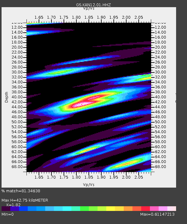
KAN12 Houston Home, Harper, KS, USA - Earthquake Result Viewer
| Earthquake location: |
Near Coast Of Central Chile |
| Earthquake latitude/longitude: |
-31.1/-71.6 |
| Earthquake time(UTC): |
2015/09/19 (262) 09:07:08 GMT |
| Earthquake Depth: |
23 km |
| Earthquake Magnitude: |
6.1 MWP |
| Earthquake Catalog/Contributor: |
NEIC PDE/NEIC COMCAT |
|
| Network: |
GS US Geological Survey Networks |
| Station: |
KAN12 Houston Home, Harper, KS, USA |
| Lat/Lon: |
37.30 N/98.00 W |
| Elevation: |
426 m |
|
| Distance: |
72.4 deg |
| Az: |
338.171 deg |
| Baz: |
156.427 deg |
| Ray Param: |
0.05366342 |
| Estimated Moho Depth: |
42.75 km |
| Estimated Crust Vp/Vs: |
1.82 |
| Assumed Crust Vp: |
6.483 km/s |
| Estimated Crust Vs: |
3.562 km/s |
| Estimated Crust Poisson's Ratio: |
0.28 |
|
| Radial Match: |
81.34638 % |
| Radial Bump: |
400 |
| Transverse Match: |
52.702713 % |
| Transverse Bump: |
400 |
| SOD ConfigId: |
1156111 |
| Insert Time: |
2015-10-03 09:28:58.393 +0000 |
| GWidth: |
2.5 |
| Max Bumps: |
400 |
| Tol: |
0.001 |
|

Signal To Noise
| Channel | StoN | STA | LTA |
| GS:KAN12:01:HHZ:20150919T09:18:01.654998Z | 7.9637465 | 1.0195189E-6 | 1.2802E-7 |
| GS:KAN12:01:HHN:20150919T09:18:01.654998Z | 1.5595005 | 4.5412088E-7 | 2.911964E-7 |
| GS:KAN12:01:HHE:20150919T09:18:01.654998Z | 0.9466529 | 3.7199143E-7 | 3.929544E-7 |
| Arrivals |
| Ps | 5.6 SECOND |
| PpPs | 18 SECOND |
| PsPs/PpSs | 24 SECOND |


