You are here: Home > Network List > ZQ15 - Taku Glacier Stations List
> Station GAGA Taku Glacier, Alaska, USA > Earthquake Result Viewer
GAGA Taku Glacier, Alaska, USA - Earthquake Result Viewer
| Earthquake location: |
Southern Peru |
| Earthquake latitude/longitude: |
-15.7/-72.0 |
| Earthquake time(UTC): |
2016/08/15 (228) 02:59:00 GMT |
| Earthquake Depth: |
20 km |
| Earthquake Magnitude: |
5.5 mwb |
| Earthquake Catalog/Contributor: |
NEIC PDE/ |
|
| Network: |
ZQ Taku Glacier |
| Station: |
GAGA Taku Glacier, Alaska, USA |
| Lat/Lon: |
58.44 N/134.05 W |
| Elevation: |
258 m |
|
| Distance: |
89.5 deg |
| Az: |
332.32 deg |
| Baz: |
121.693 deg |
| Ray Param: |
0.04182177 |
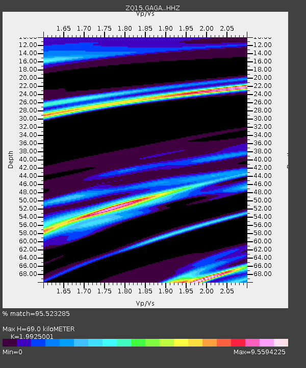
| Estimated Moho Depth: |
69.0 km |
| Estimated Crust Vp/Vs: |
1.99 |
| Assumed Crust Vp: |
6.566 km/s |
| Estimated Crust Vs: |
3.295 km/s |
| Estimated Crust Poisson's Ratio: |
0.33 |
|
| Radial Match: |
95.523285 % |
| Radial Bump: |
229 |
| Transverse Match: |
67.47387 % |
| Transverse Bump: |
400 |
| SOD ConfigId: |
11737051 |
| Insert Time: |
2019-04-25 06:59:40.947 +0000 |
| GWidth: |
2.5 |
| Max Bumps: |
400 |
| Tol: |
0.001 |
|

Signal To Noise
| Channel | StoN | STA | LTA |
| ZQ:GAGA: :HHZ:20160815T03:11:24.800012Z | 1.1556612 | 5.4561747E-7 | 4.7212575E-7 |
| ZQ:GAGA: :HH1:20160815T03:11:24.800012Z | 1.6090739 | 5.6213303E-6 | 3.493519E-6 |
| ZQ:GAGA: :HH2:20160815T03:11:24.800012Z | 0.74382406 | 1.0343961E-5 | 1.3906462E-5 |
| Arrivals |
| Ps | 11 SECOND |
| PpPs | 31 SECOND |
| PsPs/PpSs | 41 SECOND |


