You are here: Home > Network List > 8G - 2016 Pedernales Earthquake Aftershock Deployment Ecuador Stations List
> Station EC04 EC04 > Earthquake Result Viewer
EC04 EC04 - Earthquake Result Viewer
| Earthquake location: |
South Georgia Island Region |
| Earthquake latitude/longitude: |
-55.3/-31.9 |
| Earthquake time(UTC): |
2016/08/19 (232) 07:32:22 GMT |
| Earthquake Depth: |
10 km |
| Earthquake Magnitude: |
7.4 MO |
| Earthquake Catalog/Contributor: |
NEIC PDE/NEIC COMCAT |
|
| Network: |
8G 2016 Pedernales Earthquake Aftershock Deployment Ecuador |
| Station: |
EC04 EC04 |
| Lat/Lon: |
0.29 N/79.61 W |
| Elevation: |
128 m |
|
| Distance: |
67.6 deg |
| Az: |
306.92 deg |
| Baz: |
152.823 deg |
| Ray Param: |
0.056829732 |
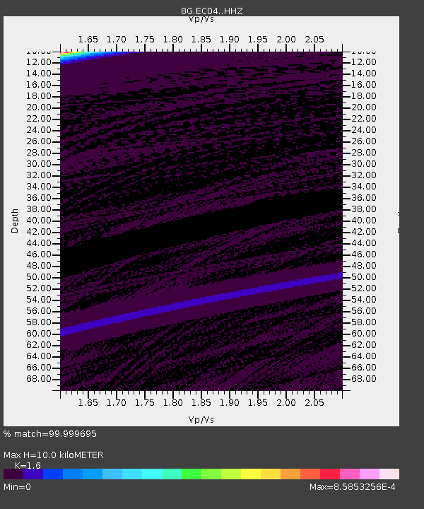
| Estimated Moho Depth: |
10.0 km |
| Estimated Crust Vp/Vs: |
1.60 |
| Assumed Crust Vp: |
6.472 km/s |
| Estimated Crust Vs: |
4.045 km/s |
| Estimated Crust Poisson's Ratio: |
0.18 |
|
| Radial Match: |
99.999695 % |
| Radial Bump: |
2 |
| Transverse Match: |
99.9997 % |
| Transverse Bump: |
2 |
| SOD ConfigId: |
11737051 |
| Insert Time: |
2019-04-25 07:10:24.300 +0000 |
| GWidth: |
2.5 |
| Max Bumps: |
400 |
| Tol: |
0.001 |
|
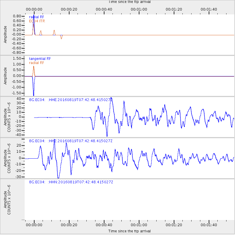
Signal To Noise
| Channel | StoN | STA | LTA |
| 8G:EC04: :HHZ:20160819T07:42:48.415027Z | 51.21761 | 8.320742E-6 | 1.6245862E-7 |
| $trig.getChannelId() | $trig.getValue() | $trig.getSTA() | $trig.getLTA() |
| 8G:EC04: :HHE:20160819T07:42:48.415027Z | 49.63615 | 1.1553371E-5 | 2.3276122E-7 |
| Arrivals |
| Ps | 1.0 SECOND |
| PpPs | 3.8 SECOND |
| PsPs/PpSs | 4.8 SECOND |


