You are here: Home > Network List > C1 - Red Sismologica Nacional Stations List
> Station CO02 Combarbala > Earthquake Result Viewer
CO02 Combarbala - Earthquake Result Viewer
| Earthquake location: |
South Georgia Island Region |
| Earthquake latitude/longitude: |
-55.3/-31.9 |
| Earthquake time(UTC): |
2016/08/19 (232) 07:32:22 GMT |
| Earthquake Depth: |
10 km |
| Earthquake Magnitude: |
7.4 MO |
| Earthquake Catalog/Contributor: |
NEIC PDE/NEIC COMCAT |
|
| Network: |
C1 Red Sismologica Nacional |
| Station: |
CO02 Combarbala |
| Lat/Lon: |
31.20 S/71.00 W |
| Elevation: |
1149 m |
|
| Distance: |
36.6 deg |
| Az: |
294.979 deg |
| Baz: |
142.817 deg |
| Ray Param: |
0.076613985 |
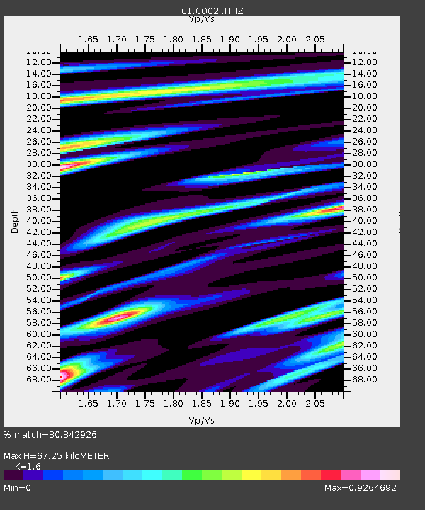
| Estimated Moho Depth: |
67.25 km |
| Estimated Crust Vp/Vs: |
1.60 |
| Assumed Crust Vp: |
6.481 km/s |
| Estimated Crust Vs: |
4.05 km/s |
| Estimated Crust Poisson's Ratio: |
0.18 |
|
| Radial Match: |
80.842926 % |
| Radial Bump: |
400 |
| Transverse Match: |
72.94517 % |
| Transverse Bump: |
400 |
| SOD ConfigId: |
11737051 |
| Insert Time: |
2019-04-25 07:11:24.353 +0000 |
| GWidth: |
2.5 |
| Max Bumps: |
400 |
| Tol: |
0.001 |
|

Signal To Noise
| Channel | StoN | STA | LTA |
| C1:CO02: :HHZ:20160819T07:38:57.849994Z | 46.828354 | 2.8671737E-5 | 6.12273E-7 |
| C1:CO02: :HHN:20160819T07:38:57.849994Z | 16.37033 | 1.4092595E-5 | 8.60862E-7 |
| C1:CO02: :HHE:20160819T07:38:57.849994Z | 14.640227 | 9.371855E-6 | 6.4014415E-7 |
| Arrivals |
| Ps | 6.8 SECOND |
| PpPs | 25 SECOND |
| PsPs/PpSs | 32 SECOND |


