You are here: Home > Network List > US - United States National Seismic Network Stations List
> Station ISCO Idaho Springs, Colorado, USA > Earthquake Result Viewer
ISCO Idaho Springs, Colorado, USA - Earthquake Result Viewer

| Earthquake location: |
South Of Alaska |
| Earthquake latitude/longitude: |
53.8/-161.1 |
| Earthquake time(UTC): |
2002/05/25 (145) 05:36:31 GMT |
| Earthquake Depth: |
33 km |
| Earthquake Magnitude: |
5.5 MB, 6.1 MS, 6.5 MW, 6.4 MW |
| Earthquake Catalog/Contributor: |
WHDF/NEIC |
|
| Network: |
US United States National Seismic Network |
| Station: |
ISCO Idaho Springs, Colorado, USA |
| Lat/Lon: |
39.80 N/105.61 W |
| Elevation: |
2743 m |
|
| Distance: |
39.5 deg |
| Az: |
87.59 deg |
| Baz: |
309.734 deg |
| Ray Param: |
0.074910685 |
| Estimated Moho Depth: |
41.5 km |
| Estimated Crust Vp/Vs: |
1.83 |
| Assumed Crust Vp: |
6.159 km/s |
| Estimated Crust Vs: |
3.37 km/s |
| Estimated Crust Poisson's Ratio: |
0.29 |
|
| Radial Match: |
94.36065 % |
| Radial Bump: |
299 |
| Transverse Match: |
79.66711 % |
| Transverse Bump: |
400 |
| SOD ConfigId: |
110165 |
| Insert Time: |
2010-03-05 06:12:48.069 +0000 |
| GWidth: |
2.5 |
| Max Bumps: |
400 |
| Tol: |
0.001 |
|
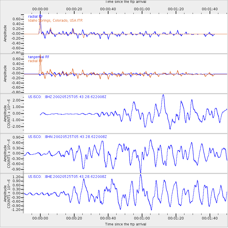
Signal To Noise
| Channel | StoN | STA | LTA |
| US:ISCO: :BHN:20020525T05:43:28.622008Z | 0.92970884 | 4.5353065E-8 | 4.878201E-8 |
| US:ISCO: :BHE:20020525T05:43:28.622008Z | 1.1368984 | 5.0236785E-8 | 4.418758E-8 |
| US:ISCO: :BHZ:20020525T05:43:28.622008Z | 1.6435794 | 9.989045E-8 | 6.0776166E-8 |
| Arrivals |
| Ps | 5.9 SECOND |
| PpPs | 18 SECOND |
| PsPs/PpSs | 24 SECOND |


