You are here: Home > Network List > N4 - Central and EAstern US Network Stations List
> Station 352A Blakely, GA, USA > Earthquake Result Viewer
352A Blakely, GA, USA - Earthquake Result Viewer
| Earthquake location: |
South Georgia Island Region |
| Earthquake latitude/longitude: |
-55.3/-31.9 |
| Earthquake time(UTC): |
2016/08/19 (232) 07:32:22 GMT |
| Earthquake Depth: |
10 km |
| Earthquake Magnitude: |
7.4 MO |
| Earthquake Catalog/Contributor: |
NEIC PDE/NEIC COMCAT |
|
| Network: |
N4 Central and EAstern US Network |
| Station: |
352A Blakely, GA, USA |
| Lat/Lon: |
31.48 N/84.93 W |
| Elevation: |
101 m |
|
| Distance: |
97.6 deg |
| Az: |
316.503 deg |
| Baz: |
152.596 deg |
| Ray Param: |
0.040158372 |
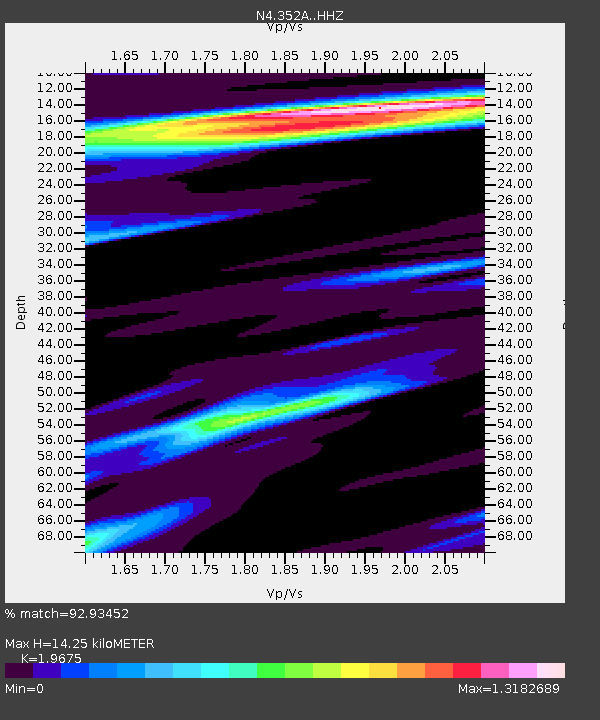
| Estimated Moho Depth: |
14.25 km |
| Estimated Crust Vp/Vs: |
1.97 |
| Assumed Crust Vp: |
6.347 km/s |
| Estimated Crust Vs: |
3.226 km/s |
| Estimated Crust Poisson's Ratio: |
0.33 |
|
| Radial Match: |
92.93452 % |
| Radial Bump: |
280 |
| Transverse Match: |
84.76647 % |
| Transverse Bump: |
317 |
| SOD ConfigId: |
11737051 |
| Insert Time: |
2019-04-25 07:13:00.989 +0000 |
| GWidth: |
2.5 |
| Max Bumps: |
400 |
| Tol: |
0.001 |
|

Signal To Noise
| Channel | StoN | STA | LTA |
| N4:352A: :HHZ:20160819T07:45:25.43999Z | 34.384644 | 4.473749E-6 | 1.3010892E-7 |
| N4:352A: :HHN:20160819T07:45:25.43999Z | 7.781692 | 1.2598659E-6 | 1.6190128E-7 |
| N4:352A: :HHE:20160819T07:45:25.43999Z | 3.0551102 | 6.381503E-7 | 2.0887964E-7 |
| Arrivals |
| Ps | 2.2 SECOND |
| PpPs | 6.6 SECOND |
| PsPs/PpSs | 8.8 SECOND |


