You are here: Home > Network List > N4 - Central and EAstern US Network Stations List
> Station Y58A Scranton, SC, USA > Earthquake Result Viewer
Y58A Scranton, SC, USA - Earthquake Result Viewer
| Earthquake location: |
South Georgia Island Region |
| Earthquake latitude/longitude: |
-55.3/-31.9 |
| Earthquake time(UTC): |
2016/08/19 (232) 07:32:22 GMT |
| Earthquake Depth: |
10 km |
| Earthquake Magnitude: |
7.4 MO |
| Earthquake Catalog/Contributor: |
NEIC PDE/NEIC COMCAT |
|
| Network: |
N4 Central and EAstern US Network |
| Station: |
Y58A Scranton, SC, USA |
| Lat/Lon: |
33.91 N/79.67 W |
| Elevation: |
19 m |
|
| Distance: |
97.8 deg |
| Az: |
321.597 deg |
| Baz: |
154.742 deg |
| Ray Param: |
0.04009723 |
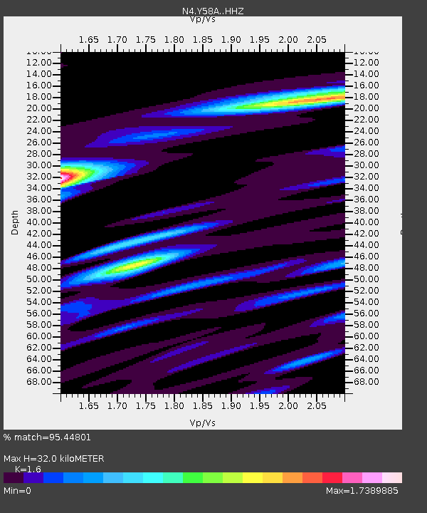
| Estimated Moho Depth: |
32.0 km |
| Estimated Crust Vp/Vs: |
1.60 |
| Assumed Crust Vp: |
6.24 km/s |
| Estimated Crust Vs: |
3.9 km/s |
| Estimated Crust Poisson's Ratio: |
0.18 |
|
| Radial Match: |
95.44801 % |
| Radial Bump: |
400 |
| Transverse Match: |
78.96648 % |
| Transverse Bump: |
400 |
| SOD ConfigId: |
11737051 |
| Insert Time: |
2019-04-25 07:13:07.161 +0000 |
| GWidth: |
2.5 |
| Max Bumps: |
400 |
| Tol: |
0.001 |
|

Signal To Noise
| Channel | StoN | STA | LTA |
| N4:Y58A: :HHZ:20160819T07:45:26.299976Z | 31.297016 | 3.5922917E-6 | 1.1478065E-7 |
| N4:Y58A: :HHN:20160819T07:45:26.299976Z | 6.266235 | 1.5933402E-6 | 2.5427394E-7 |
| N4:Y58A: :HHE:20160819T07:45:26.299976Z | 2.4184058 | 6.5446255E-7 | 2.7061733E-7 |
| Arrivals |
| Ps | 3.1 SECOND |
| PpPs | 13 SECOND |
| PsPs/PpSs | 16 SECOND |


