You are here: Home > Network List > NR - NARS Array Stations List
> Station NE204 Xaudum > Earthquake Result Viewer
NE204 Xaudum - Earthquake Result Viewer
| Earthquake location: |
South Georgia Island Region |
| Earthquake latitude/longitude: |
-55.3/-31.9 |
| Earthquake time(UTC): |
2016/08/19 (232) 07:32:22 GMT |
| Earthquake Depth: |
10 km |
| Earthquake Magnitude: |
7.4 MO |
| Earthquake Catalog/Contributor: |
NEIC PDE/NEIC COMCAT |
|
| Network: |
NR NARS Array |
| Station: |
NE204 Xaudum |
| Lat/Lon: |
18.54 S/21.34 E |
| Elevation: |
1060 m |
|
| Distance: |
54.3 deg |
| Az: |
69.452 deg |
| Baz: |
214.323 deg |
| Ray Param: |
0.06553155 |
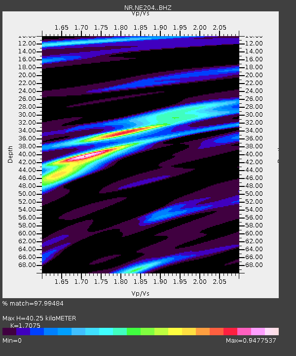
| Estimated Moho Depth: |
40.25 km |
| Estimated Crust Vp/Vs: |
1.71 |
| Assumed Crust Vp: |
6.577 km/s |
| Estimated Crust Vs: |
3.852 km/s |
| Estimated Crust Poisson's Ratio: |
0.24 |
|
| Radial Match: |
97.99484 % |
| Radial Bump: |
238 |
| Transverse Match: |
89.444374 % |
| Transverse Bump: |
400 |
| SOD ConfigId: |
11737051 |
| Insert Time: |
2019-04-25 07:13:12.266 +0000 |
| GWidth: |
2.5 |
| Max Bumps: |
400 |
| Tol: |
0.001 |
|

Signal To Noise
| Channel | StoN | STA | LTA |
| NR:NE204: :BHZ:20160819T07:41:17.658984Z | 48.837227 | 1.1056939E-5 | 2.2640391E-7 |
| NR:NE204: :BHN:20160819T07:41:17.658984Z | 17.348877 | 5.3549693E-6 | 3.0866374E-7 |
| NR:NE204: :BHE:20160819T07:41:17.658984Z | 21.692 | 3.4964191E-6 | 1.6118473E-7 |
| Arrivals |
| Ps | 4.6 SECOND |
| PpPs | 16 SECOND |
| PsPs/PpSs | 20 SECOND |


