You are here: Home > Network List > IW - Intermountain West Stations List
> Station MOOW Moose Ponds, Wyoming, USA > Earthquake Result Viewer
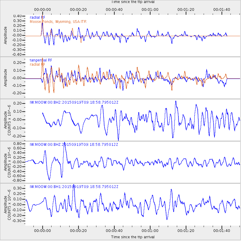
MOOW Moose Ponds, Wyoming, USA - Earthquake Result Viewer
*The percent match for this event was below the threshold and hence no stack was calculated.
| Earthquake location: |
Near Coast Of Central Chile |
| Earthquake latitude/longitude: |
-31.1/-71.6 |
| Earthquake time(UTC): |
2015/09/19 (262) 09:07:08 GMT |
| Earthquake Depth: |
23 km |
| Earthquake Magnitude: |
6.1 MWP |
| Earthquake Catalog/Contributor: |
NEIC PDE/NEIC COMCAT |
|
| Network: |
IW Intermountain West |
| Station: |
MOOW Moose Ponds, Wyoming, USA |
| Lat/Lon: |
43.75 N/110.74 W |
| Elevation: |
2128 m |
|
| Distance: |
82.7 deg |
| Az: |
332.538 deg |
| Baz: |
146.921 deg |
| Ray Param: |
$rayparam |
*The percent match for this event was below the threshold and hence was not used in the summary stack. |
|
| Radial Match: |
79.23529 % |
| Radial Bump: |
400 |
| Transverse Match: |
69.26077 % |
| Transverse Bump: |
400 |
| SOD ConfigId: |
1156111 |
| Insert Time: |
2015-10-03 09:31:25.677 +0000 |
| GWidth: |
2.5 |
| Max Bumps: |
400 |
| Tol: |
0.001 |
|
Signal To Noise
| Channel | StoN | STA | LTA |
| IW:MOOW:00:BHZ:20150919T09:18:58.795012Z | 5.034885 | 4.1141087E-7 | 8.171207E-8 |
| IW:MOOW:00:BH1:20150919T09:18:58.795012Z | 1.7601084 | 9.404163E-8 | 5.3429456E-8 |
| IW:MOOW:00:BH2:20150919T09:18:58.795012Z | 1.5355909 | 9.940984E-8 | 6.473719E-8 |
| Arrivals |
| Ps | |
| PpPs | |
| PsPs/PpSs | |


