You are here: Home > Network List > ON - RSIS-Rede Sismografica do Sul e Sudeste Observatorio Nacional, Brazil Stations List
> Station MAN01 OBSN: [MAN01] Mangaratiba, RJ > Earthquake Result Viewer
MAN01 OBSN: [MAN01] Mangaratiba, RJ - Earthquake Result Viewer
| Earthquake location: |
South Georgia Island Region |
| Earthquake latitude/longitude: |
-55.3/-31.9 |
| Earthquake time(UTC): |
2016/08/19 (232) 07:32:22 GMT |
| Earthquake Depth: |
10 km |
| Earthquake Magnitude: |
7.4 MO |
| Earthquake Catalog/Contributor: |
NEIC PDE/NEIC COMCAT |
|
| Network: |
ON RSIS-Rede Sismografica do Sul e Sudeste Observatorio Nacional, Brazil |
| Station: |
MAN01 OBSN: [MAN01] Mangaratiba, RJ |
| Lat/Lon: |
22.87 S/43.96 W |
| Elevation: |
617 m |
|
| Distance: |
33.6 deg |
| Az: |
339.708 deg |
| Baz: |
167.595 deg |
| Ray Param: |
0.07811152 |
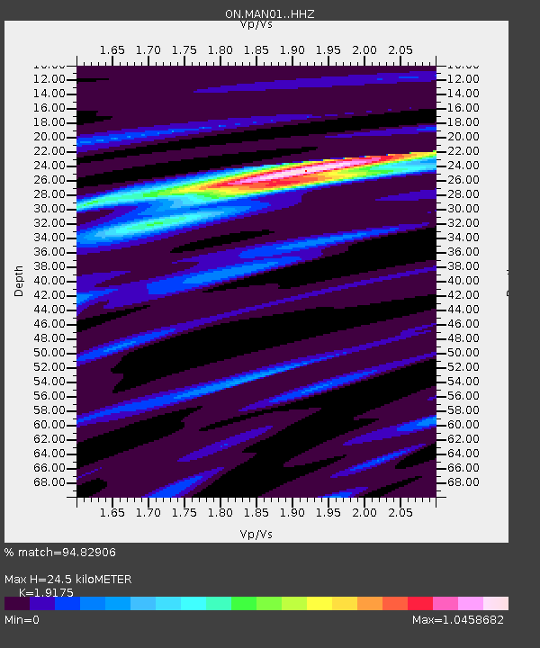
| Estimated Moho Depth: |
24.5 km |
| Estimated Crust Vp/Vs: |
1.92 |
| Assumed Crust Vp: |
6.472 km/s |
| Estimated Crust Vs: |
3.375 km/s |
| Estimated Crust Poisson's Ratio: |
0.31 |
|
| Radial Match: |
94.82906 % |
| Radial Bump: |
200 |
| Transverse Match: |
91.5244 % |
| Transverse Bump: |
302 |
| SOD ConfigId: |
11737051 |
| Insert Time: |
2019-04-25 07:13:32.681 +0000 |
| GWidth: |
2.5 |
| Max Bumps: |
400 |
| Tol: |
0.001 |
|

Signal To Noise
| Channel | StoN | STA | LTA |
| ON:MAN01: :HHZ:20160819T07:38:32.34801Z | 15.160272 | 6.5711033E-6 | 4.3344232E-7 |
| ON:MAN01: :HHN:20160819T07:38:32.34801Z | 11.419546 | 3.880843E-6 | 3.3984213E-7 |
| ON:MAN01: :HHE:20160819T07:38:32.34801Z | 9.480472 | 2.6139453E-6 | 2.757189E-7 |
| Arrivals |
| Ps | 3.7 SECOND |
| PpPs | 10 SECOND |
| PsPs/PpSs | 14 SECOND |


