You are here: Home > Network List > S - Seismographs in Schools Projects Stations List
> Station AULHS Lilydale High School, Lilydale, TAS > Earthquake Result Viewer
AULHS Lilydale High School, Lilydale, TAS - Earthquake Result Viewer
| Earthquake location: |
South Georgia Island Region |
| Earthquake latitude/longitude: |
-55.3/-31.9 |
| Earthquake time(UTC): |
2016/08/19 (232) 07:32:22 GMT |
| Earthquake Depth: |
10 km |
| Earthquake Magnitude: |
7.4 MO |
| Earthquake Catalog/Contributor: |
NEIC PDE/NEIC COMCAT |
|
| Network: |
S Seismographs in Schools Projects |
| Station: |
AULHS Lilydale High School, Lilydale, TAS |
| Lat/Lon: |
41.25 S/147.21 E |
| Elevation: |
173 m |
|
| Distance: |
83.8 deg |
| Az: |
179.359 deg |
| Baz: |
180.486 deg |
| Ray Param: |
0.04594677 |
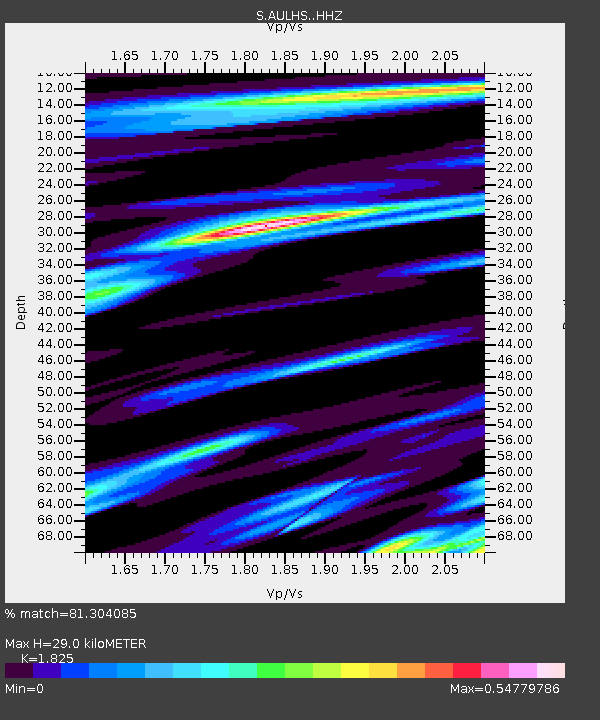
| Estimated Moho Depth: |
29.0 km |
| Estimated Crust Vp/Vs: |
1.83 |
| Assumed Crust Vp: |
6.39 km/s |
| Estimated Crust Vs: |
3.501 km/s |
| Estimated Crust Poisson's Ratio: |
0.29 |
|
| Radial Match: |
81.304085 % |
| Radial Bump: |
400 |
| Transverse Match: |
83.23271 % |
| Transverse Bump: |
400 |
| SOD ConfigId: |
11737051 |
| Insert Time: |
2019-04-25 07:14:40.978 +0000 |
| GWidth: |
2.5 |
| Max Bumps: |
400 |
| Tol: |
0.001 |
|

Signal To Noise
| Channel | StoN | STA | LTA |
| S:AULHS: :HHZ:20160819T07:44:20.850024Z | 3.3012226 | 6.184104E-6 | 1.8732769E-6 |
| S:AULHS: :HHN:20160819T07:44:20.850024Z | 1.2358738 | 1.5983744E-6 | 1.2933152E-6 |
| S:AULHS: :HHE:20160819T07:44:20.850024Z | 2.043782 | 1.9152453E-6 | 9.371085E-7 |
| Arrivals |
| Ps | 3.8 SECOND |
| PpPs | 13 SECOND |
| PsPs/PpSs | 16 SECOND |


