You are here: Home > Network List > WC - Curacao Seismic Network Stations List
> Station HATO Hato, Curacao > Earthquake Result Viewer
HATO Hato, Curacao - Earthquake Result Viewer
| Earthquake location: |
South Georgia Island Region |
| Earthquake latitude/longitude: |
-55.3/-31.9 |
| Earthquake time(UTC): |
2016/08/19 (232) 07:32:22 GMT |
| Earthquake Depth: |
10 km |
| Earthquake Magnitude: |
7.4 MO |
| Earthquake Catalog/Contributor: |
NEIC PDE/NEIC COMCAT |
|
| Network: |
WC Curacao Seismic Network |
| Station: |
HATO Hato, Curacao |
| Lat/Lon: |
12.18 N/68.96 W |
| Elevation: |
40 m |
|
| Distance: |
74.1 deg |
| Az: |
322.258 deg |
| Baz: |
159.044 deg |
| Ray Param: |
0.052560486 |
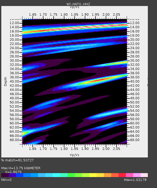
| Estimated Moho Depth: |
13.75 km |
| Estimated Crust Vp/Vs: |
1.91 |
| Assumed Crust Vp: |
5.88 km/s |
| Estimated Crust Vs: |
3.083 km/s |
| Estimated Crust Poisson's Ratio: |
0.31 |
|
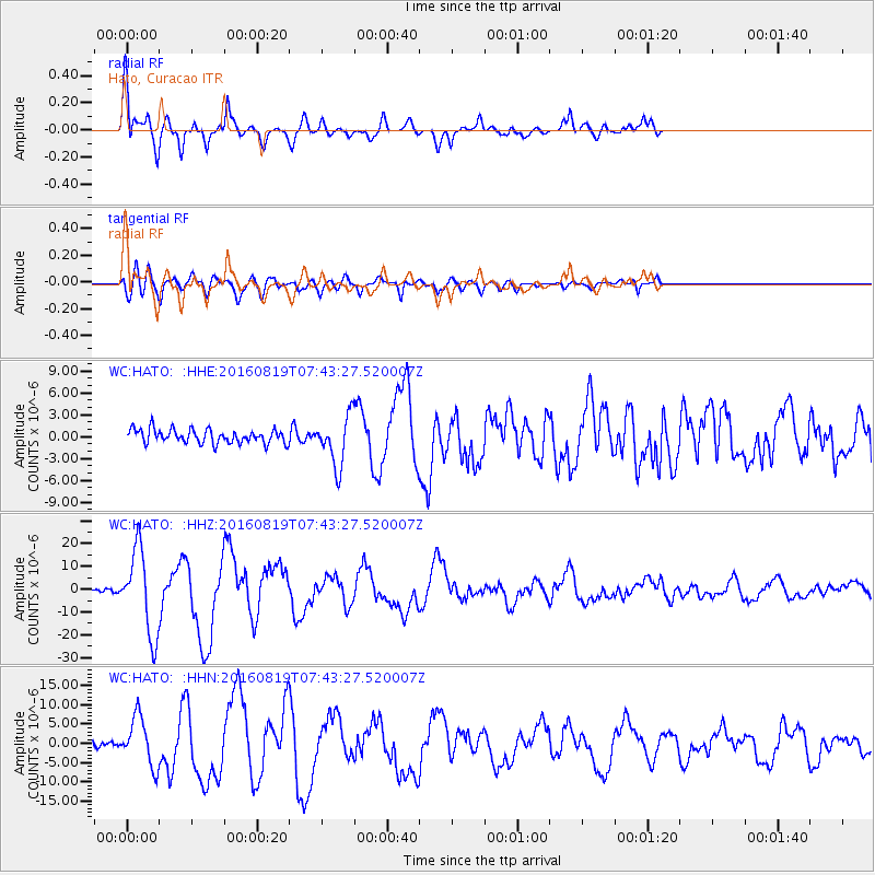
| Radial Match: |
91.53727 % |
| Radial Bump: |
400 |
| Transverse Match: |
77.714 % |
| Transverse Bump: |
400 |
| SOD ConfigId: |
11737051 |
| Insert Time: |
2019-04-25 07:15:15.295 +0000 |
| GWidth: |
2.5 |
| Max Bumps: |
400 |
| Tol: |
0.001 |
|
Signal To Noise
| Channel | StoN | STA | LTA |
| WC:HATO: :HHZ:20160819T07:43:27.520007Z | 27.20381 | 1.835542E-5 | 6.7473707E-7 |
| WC:HATO: :HHN:20160819T07:43:27.520007Z | 7.2882395 | 6.303762E-6 | 8.649224E-7 |
| WC:HATO: :HHE:20160819T07:43:27.520007Z | 3.8197725 | 3.6420445E-6 | 9.5347156E-7 |
| Arrivals |
| Ps | 2.2 SECOND |
| PpPs | 6.6 SECOND |
| PsPs/PpSs | 8.8 SECOND |


