You are here: Home > Network List > WI - West Indies IPGP Network Stations List
> Station BIM Morne Bigot, Anses d'Arlets, Martinique > Earthquake Result Viewer
BIM Morne Bigot, Anses d'Arlets, Martinique - Earthquake Result Viewer
| Earthquake location: |
South Georgia Island Region |
| Earthquake latitude/longitude: |
-55.3/-31.9 |
| Earthquake time(UTC): |
2016/08/19 (232) 07:32:22 GMT |
| Earthquake Depth: |
10 km |
| Earthquake Magnitude: |
7.4 MO |
| Earthquake Catalog/Contributor: |
NEIC PDE/NEIC COMCAT |
|
| Network: |
WI West Indies IPGP Network |
| Station: |
BIM Morne Bigot, Anses d'Arlets, Martinique |
| Lat/Lon: |
14.52 N/61.07 W |
| Elevation: |
391 m |
|
| Distance: |
73.8 deg |
| Az: |
330.602 deg |
| Baz: |
163.168 deg |
| Ray Param: |
0.052757487 |
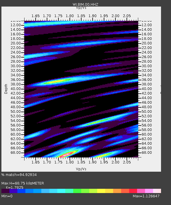
| Estimated Moho Depth: |
68.75 km |
| Estimated Crust Vp/Vs: |
1.78 |
| Assumed Crust Vp: |
5.88 km/s |
| Estimated Crust Vs: |
3.299 km/s |
| Estimated Crust Poisson's Ratio: |
0.27 |
|
| Radial Match: |
94.92934 % |
| Radial Bump: |
400 |
| Transverse Match: |
86.94209 % |
| Transverse Bump: |
400 |
| SOD ConfigId: |
11737051 |
| Insert Time: |
2019-04-25 07:15:16.684 +0000 |
| GWidth: |
2.5 |
| Max Bumps: |
400 |
| Tol: |
0.001 |
|
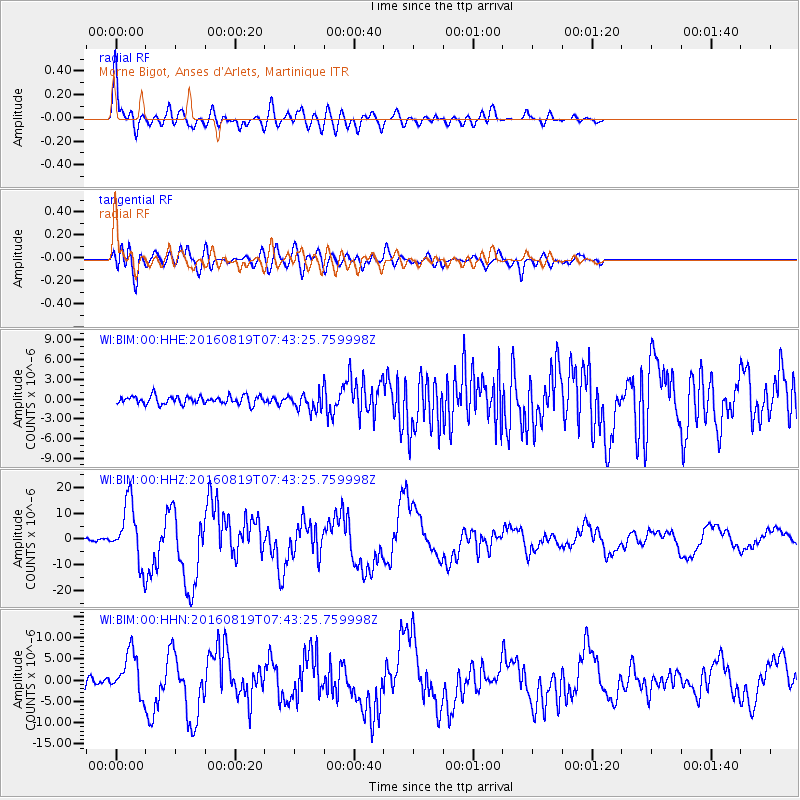
Signal To Noise
| Channel | StoN | STA | LTA |
| WI:BIM:00:HHZ:20160819T07:43:25.759998Z | 27.101854 | 1.1816731E-5 | 4.3601187E-7 |
| WI:BIM:00:HHN:20160819T07:43:25.759998Z | 7.695435 | 5.04324E-6 | 6.553548E-7 |
| WI:BIM:00:HHE:20160819T07:43:25.759998Z | 2.5434053 | 1.559614E-6 | 6.131991E-7 |
| Arrivals |
| Ps | 9.4 SECOND |
| PpPs | 32 SECOND |
| PsPs/PpSs | 41 SECOND |


