You are here: Home > Network List > YT07 - POLENET Stations List
> Station HOWE HOWE > Earthquake Result Viewer
HOWE HOWE - Earthquake Result Viewer
| Earthquake location: |
South Georgia Island Region |
| Earthquake latitude/longitude: |
-55.3/-31.9 |
| Earthquake time(UTC): |
2016/08/19 (232) 07:32:22 GMT |
| Earthquake Depth: |
10 km |
| Earthquake Magnitude: |
7.4 MO |
| Earthquake Catalog/Contributor: |
NEIC PDE/NEIC COMCAT |
|
| Network: |
YT POLENET |
| Station: |
HOWE HOWE |
| Lat/Lon: |
87.42 S/149.43 W |
| Elevation: |
2607 m |
|
| Distance: |
36.1 deg |
| Az: |
183.918 deg |
| Baz: |
120.679 deg |
| Ray Param: |
0.076861456 |
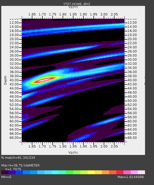
| Estimated Moho Depth: |
39.75 km |
| Estimated Crust Vp/Vs: |
1.71 |
| Assumed Crust Vp: |
6.182 km/s |
| Estimated Crust Vs: |
3.62 km/s |
| Estimated Crust Poisson's Ratio: |
0.24 |
|
| Radial Match: |
91.341034 % |
| Radial Bump: |
291 |
| Transverse Match: |
77.23162 % |
| Transverse Bump: |
400 |
| SOD ConfigId: |
11737051 |
| Insert Time: |
2019-04-25 07:15:30.322 +0000 |
| GWidth: |
2.5 |
| Max Bumps: |
400 |
| Tol: |
0.001 |
|

Signal To Noise
| Channel | StoN | STA | LTA |
| YT:HOWE: :BHZ:20160819T07:38:54.448993Z | 78.190216 | 9.549531E-6 | 1.2213204E-7 |
| YT:HOWE: :BHN:20160819T07:38:54.448993Z | 36.526485 | 2.9248229E-6 | 8.007403E-8 |
| YT:HOWE: :BHE:20160819T07:38:54.448993Z | 65.61544 | 5.862297E-6 | 8.9343246E-8 |
| Arrivals |
| Ps | 4.9 SECOND |
| PpPs | 16 SECOND |
| PsPs/PpSs | 21 SECOND |


