You are here: Home > Network List > US - United States National Seismic Network Stations List
> Station ISCO Idaho Springs, Colorado, USA > Earthquake Result Viewer
ISCO Idaho Springs, Colorado, USA - Earthquake Result Viewer
| Earthquake location: |
Primor'ye, Russia |
| Earthquake latitude/longitude: |
47.2/139.2 |
| Earthquake time(UTC): |
2003/07/27 (208) 06:25:31 GMT |
| Earthquake Depth: |
470 km |
| Earthquake Magnitude: |
6.3 MB, 6.8 MW, 6.8 MW |
| Earthquake Catalog/Contributor: |
WHDF/NEIC |
|
| Network: |
US United States National Seismic Network |
| Station: |
ISCO Idaho Springs, Colorado, USA |
| Lat/Lon: |
39.80 N/105.61 W |
| Elevation: |
2743 m |
|
| Distance: |
76.0 deg |
| Az: |
45.964 deg |
| Baz: |
320.439 deg |
| Ray Param: |
0.049892414 |
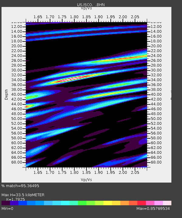
| Estimated Moho Depth: |
33.5 km |
| Estimated Crust Vp/Vs: |
1.78 |
| Assumed Crust Vp: |
6.159 km/s |
| Estimated Crust Vs: |
3.455 km/s |
| Estimated Crust Poisson's Ratio: |
0.27 |
|
| Radial Match: |
95.36495 % |
| Radial Bump: |
400 |
| Transverse Match: |
89.766754 % |
| Transverse Bump: |
400 |
| SOD ConfigId: |
110177 |
| Insert Time: |
2010-03-05 06:13:35.031 +0000 |
| GWidth: |
2.5 |
| Max Bumps: |
400 |
| Tol: |
0.001 |
|

Signal To Noise
| Channel | StoN | STA | LTA |
| US:ISCO: :BHN:20030727T06:35:58.564014Z | 20.357218 | 6.9136E-7 | 3.396142E-8 |
| US:ISCO: :BHE:20030727T06:35:58.564014Z | 20.045336 | 6.7064406E-7 | 3.3456367E-8 |
| US:ISCO: :BHZ:20030727T06:35:58.564014Z | 65.93271 | 2.9569983E-6 | 4.4848733E-8 |
| Arrivals |
| Ps | 4.4 SECOND |
| PpPs | 15 SECOND |
| PsPs/PpSs | 19 SECOND |


