You are here: Home > Network List > TA - USArray Transportable Network (new EarthScope stations) Stations List
> Station H22K Ishtalitna Creek, AK, USA > Earthquake Result Viewer
H22K Ishtalitna Creek, AK, USA - Earthquake Result Viewer
| Earthquake location: |
Off East Coast Of Honshu, Japan |
| Earthquake latitude/longitude: |
40.4/143.7 |
| Earthquake time(UTC): |
2016/08/20 (233) 09:01:26 GMT |
| Earthquake Depth: |
10 km |
| Earthquake Magnitude: |
6.0 MO |
| Earthquake Catalog/Contributor: |
NEIC PDE/NEIC ALERT |
|
| Network: |
TA USArray Transportable Network (new EarthScope stations) |
| Station: |
H22K Ishtalitna Creek, AK, USA |
| Lat/Lon: |
65.89 N/151.38 W |
| Elevation: |
561 m |
|
| Distance: |
43.9 deg |
| Az: |
32.477 deg |
| Baz: |
267.505 deg |
| Ray Param: |
0.072277054 |
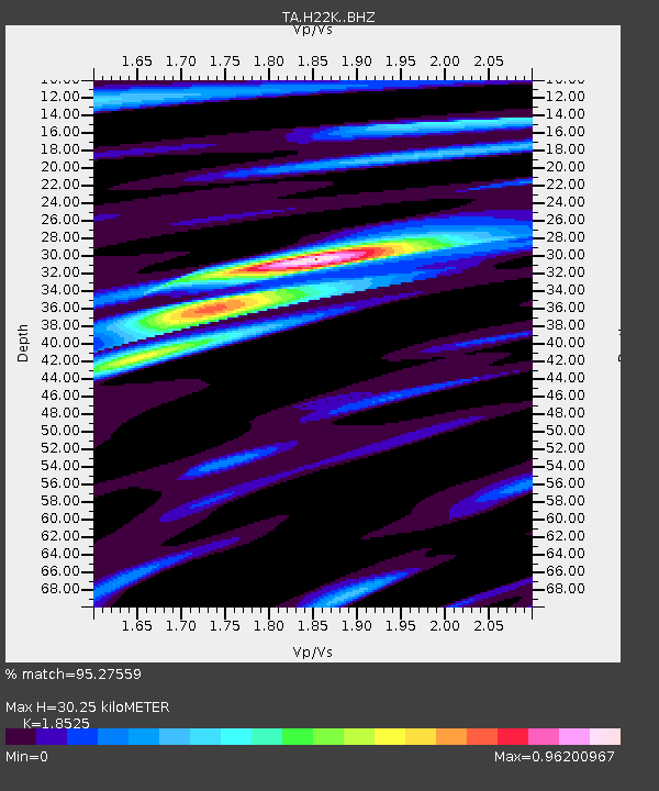
| Estimated Moho Depth: |
30.25 km |
| Estimated Crust Vp/Vs: |
1.85 |
| Assumed Crust Vp: |
6.566 km/s |
| Estimated Crust Vs: |
3.544 km/s |
| Estimated Crust Poisson's Ratio: |
0.29 |
|
| Radial Match: |
95.27559 % |
| Radial Bump: |
354 |
| Transverse Match: |
82.79599 % |
| Transverse Bump: |
400 |
| SOD ConfigId: |
11737051 |
| Insert Time: |
2019-04-25 07:37:43.100 +0000 |
| GWidth: |
2.5 |
| Max Bumps: |
400 |
| Tol: |
0.001 |
|

Signal To Noise
| Channel | StoN | STA | LTA |
| TA:H22K: :BHZ:20160820T09:09:01.799988Z | 2.663122 | 1.6084239E-7 | 6.0396175E-8 |
| TA:H22K: :BHN:20160820T09:09:01.799988Z | 1.0784851 | 4.6553378E-8 | 4.3165524E-8 |
| TA:H22K: :BHE:20160820T09:09:01.799988Z | 0.91232455 | 5.441735E-8 | 5.964692E-8 |
| Arrivals |
| Ps | 4.2 SECOND |
| PpPs | 12 SECOND |
| PsPs/PpSs | 16 SECOND |


