You are here: Home > Network List > US - United States National Seismic Network Stations List
> Station MNTX Cornudas Mountains, Texas, USA > Earthquake Result Viewer
MNTX Cornudas Mountains, Texas, USA - Earthquake Result Viewer
| Earthquake location: |
South Of Fiji Islands |
| Earthquake latitude/longitude: |
-26.4/-177.9 |
| Earthquake time(UTC): |
2004/08/17 (230) 04:49:03 GMT |
| Earthquake Depth: |
210 km |
| Earthquake Magnitude: |
5.0 MB, 5.6 MW |
| Earthquake Catalog/Contributor: |
WHDF/NEIC |
|
| Network: |
US United States National Seismic Network |
| Station: |
MNTX Cornudas Mountains, Texas, USA |
| Lat/Lon: |
31.70 N/105.38 W |
| Elevation: |
404 m |
|
| Distance: |
90.1 deg |
| Az: |
54.404 deg |
| Baz: |
238.851 deg |
| Ray Param: |
0.04165182 |
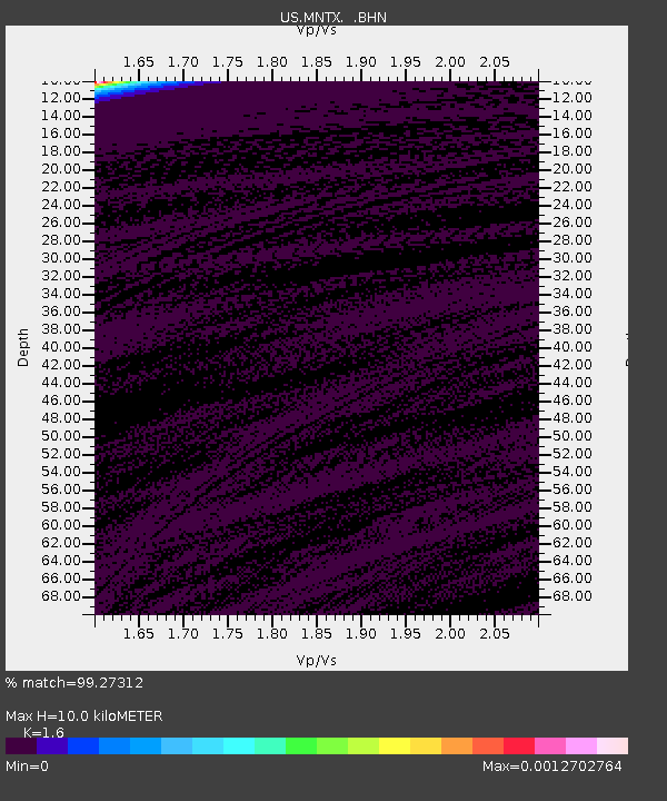
| Estimated Moho Depth: |
10.0 km |
| Estimated Crust Vp/Vs: |
1.60 |
| Assumed Crust Vp: |
6.361 km/s |
| Estimated Crust Vs: |
3.975 km/s |
| Estimated Crust Poisson's Ratio: |
0.18 |
|
| Radial Match: |
99.27312 % |
| Radial Bump: |
43 |
| Transverse Match: |
99.45153 % |
| Transverse Bump: |
34 |
| SOD ConfigId: |
110165 |
| Insert Time: |
2010-03-05 06:15:12.431 +0000 |
| GWidth: |
2.5 |
| Max Bumps: |
400 |
| Tol: |
0.001 |
|
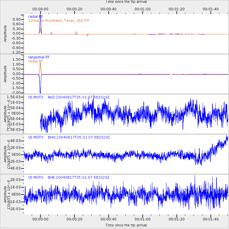
Signal To Noise
| Channel | StoN | STA | LTA |
| US:MNTX: :BHN:20040817T05:01:07.682029Z | 1.0092789 | 6.891371E-10 | 6.828014E-10 |
| US:MNTX: :BHE:20040817T05:01:07.682029Z | 0.85362315 | 4.98486E-10 | 5.839649E-10 |
| US:MNTX: :BHZ:20040817T05:01:07.682029Z | 1.399178 | 7.641721E-10 | 5.461579E-10 |
| Arrivals |
| Ps | 1.0 SECOND |
| PpPs | 4.0 SECOND |
| PsPs/PpSs | 5.0 SECOND |


