You are here: Home > Network List > TA - USArray Transportable Network (new EarthScope stations) Stations List
> Station R33M Jennings River, BC, CAN > Earthquake Result Viewer
R33M Jennings River, BC, CAN - Earthquake Result Viewer

| Earthquake location: |
Off East Coast Of Honshu, Japan |
| Earthquake latitude/longitude: |
40.4/143.7 |
| Earthquake time(UTC): |
2016/08/20 (233) 09:01:26 GMT |
| Earthquake Depth: |
10 km |
| Earthquake Magnitude: |
6.0 MO |
| Earthquake Catalog/Contributor: |
NEIC PDE/NEIC ALERT |
|
| Network: |
TA USArray Transportable Network (new EarthScope stations) |
| Station: |
R33M Jennings River, BC, CAN |
| Lat/Lon: |
59.39 N/130.97 W |
| Elevation: |
1437 m |
|
| Distance: |
54.1 deg |
| Az: |
38.997 deg |
| Baz: |
289.974 deg |
| Ray Param: |
0.06563662 |
| Estimated Moho Depth: |
38.75 km |
| Estimated Crust Vp/Vs: |
1.74 |
| Assumed Crust Vp: |
6.597 km/s |
| Estimated Crust Vs: |
3.792 km/s |
| Estimated Crust Poisson's Ratio: |
0.25 |
|
| Radial Match: |
80.3997 % |
| Radial Bump: |
400 |
| Transverse Match: |
62.79141 % |
| Transverse Bump: |
400 |
| SOD ConfigId: |
11737051 |
| Insert Time: |
2019-04-25 07:38:19.363 +0000 |
| GWidth: |
2.5 |
| Max Bumps: |
400 |
| Tol: |
0.001 |
|
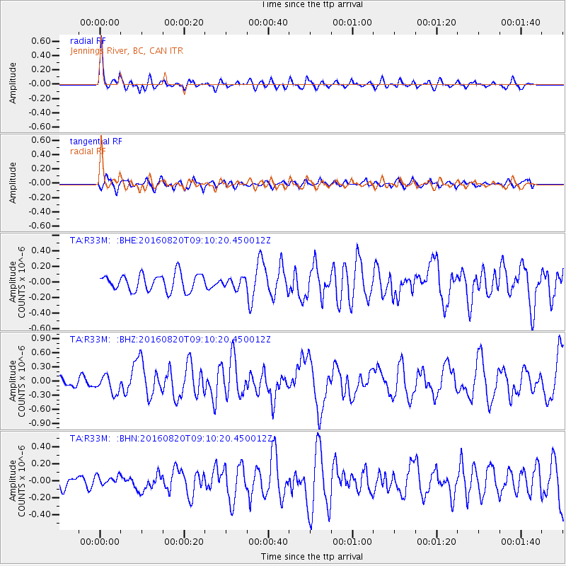
Signal To Noise
| Channel | StoN | STA | LTA |
| TA:R33M: :BHZ:20160820T09:10:20.450012Z | 2.5093 | 1.8718166E-7 | 7.459517E-8 |
| TA:R33M: :BHN:20160820T09:10:20.450012Z | 0.8747247 | 5.541084E-8 | 6.3346604E-8 |
| TA:R33M: :BHE:20160820T09:10:20.450012Z | 0.57154536 | 6.164307E-8 | 1.0785333E-7 |
| Arrivals |
| Ps | 4.6 SECOND |
| PpPs | 15 SECOND |
| PsPs/PpSs | 20 SECOND |


