You are here: Home > Network List > US - United States National Seismic Network Stations List
> Station MSO Missoula, Montana, USA > Earthquake Result Viewer
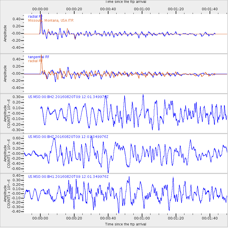
MSO Missoula, Montana, USA - Earthquake Result Viewer
*The percent match for this event was below the threshold and hence no stack was calculated.
| Earthquake location: |
Off East Coast Of Honshu, Japan |
| Earthquake latitude/longitude: |
40.4/143.7 |
| Earthquake time(UTC): |
2016/08/20 (233) 09:01:26 GMT |
| Earthquake Depth: |
10 km |
| Earthquake Magnitude: |
6.0 MO |
| Earthquake Catalog/Contributor: |
NEIC PDE/NEIC ALERT |
|
| Network: |
US United States National Seismic Network |
| Station: |
MSO Missoula, Montana, USA |
| Lat/Lon: |
46.83 N/113.94 W |
| Elevation: |
1264 m |
|
| Distance: |
69.1 deg |
| Az: |
45.873 deg |
| Baz: |
306.977 deg |
| Ray Param: |
$rayparam |
*The percent match for this event was below the threshold and hence was not used in the summary stack. |
|
| Radial Match: |
77.172356 % |
| Radial Bump: |
400 |
| Transverse Match: |
68.68893 % |
| Transverse Bump: |
400 |
| SOD ConfigId: |
11737051 |
| Insert Time: |
2019-04-25 07:38:48.434 +0000 |
| GWidth: |
2.5 |
| Max Bumps: |
400 |
| Tol: |
0.001 |
|
Signal To Noise
| Channel | StoN | STA | LTA |
| US:MSO:00:BHZ:20160820T09:12:01.349976Z | 1.9976113 | 1.2958918E-7 | 6.4872076E-8 |
| US:MSO:00:BH1:20160820T09:12:01.349976Z | 0.9276149 | 6.4291974E-8 | 6.93089E-8 |
| US:MSO:00:BH2:20160820T09:12:01.349976Z | 1.3811967 | 1.3033417E-7 | 9.436322E-8 |
| Arrivals |
| Ps | |
| PpPs | |
| PsPs/PpSs | |


