You are here: Home > Network List > US - United States National Seismic Network Stations List
> Station MNTX Cornudas Mountains, Texas, USA > Earthquake Result Viewer
MNTX Cornudas Mountains, Texas, USA - Earthquake Result Viewer
| Earthquake location: |
Southern Greece |
| Earthquake latitude/longitude: |
36.3/21.8 |
| Earthquake time(UTC): |
2008/02/20 (051) 18:27:06 GMT |
| Earthquake Depth: |
9.9 km |
| Earthquake Magnitude: |
5.7 MB, 6.1 MS, 6.1 MW, 6.1 MW |
| Earthquake Catalog/Contributor: |
WHDF/NEIC |
|
| Network: |
US United States National Seismic Network |
| Station: |
MNTX Cornudas Mountains, Texas, USA |
| Lat/Lon: |
31.70 N/105.38 W |
| Elevation: |
404 m |
|
| Distance: |
96.2 deg |
| Az: |
316.896 deg |
| Baz: |
40.368 deg |
| Ray Param: |
0.040582366 |
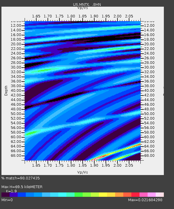
| Estimated Moho Depth: |
69.5 km |
| Estimated Crust Vp/Vs: |
1.90 |
| Assumed Crust Vp: |
6.361 km/s |
| Estimated Crust Vs: |
3.348 km/s |
| Estimated Crust Poisson's Ratio: |
0.31 |
|
| Radial Match: |
98.027435 % |
| Radial Bump: |
68 |
| Transverse Match: |
82.25026 % |
| Transverse Bump: |
203 |
| SOD ConfigId: |
2564 |
| Insert Time: |
2010-03-05 06:15:27.544 +0000 |
| GWidth: |
2.5 |
| Max Bumps: |
400 |
| Tol: |
0.001 |
|

Signal To Noise
| Channel | StoN | STA | LTA |
| US:MNTX: :BHN:20080220T18:40:02.388Z | 1.1267786 | 5.063041E-10 | 4.493377E-10 |
| US:MNTX: :BHE:20080220T18:40:02.388Z | 0.9237808 | 4.3186216E-10 | 4.674942E-10 |
| US:MNTX: :BHZ:20080220T18:40:02.388Z | 1.0656289 | 4.5689616E-10 | 4.2875728E-10 |
| Arrivals |
| Ps | 10 SECOND |
| PpPs | 31 SECOND |
| PsPs/PpSs | 41 SECOND |


