You are here: Home > Network List > US - United States National Seismic Network Stations List
> Station MNTX Cornudas Mountains, Texas, USA > Earthquake Result Viewer
MNTX Cornudas Mountains, Texas, USA - Earthquake Result Viewer
| Earthquake location: |
Southern Greece |
| Earthquake latitude/longitude: |
37.2/22.7 |
| Earthquake time(UTC): |
2008/01/06 (006) 05:14:20 GMT |
| Earthquake Depth: |
75 km |
| Earthquake Magnitude: |
6.1 MB, 6.2 MW, 6.1 MW |
| Earthquake Catalog/Contributor: |
WHDF/NEIC |
|
| Network: |
US United States National Seismic Network |
| Station: |
MNTX Cornudas Mountains, Texas, USA |
| Lat/Lon: |
31.70 N/105.38 W |
| Elevation: |
404 m |
|
| Distance: |
96.0 deg |
| Az: |
317.568 deg |
| Baz: |
39.191 deg |
| Ray Param: |
0.040580623 |
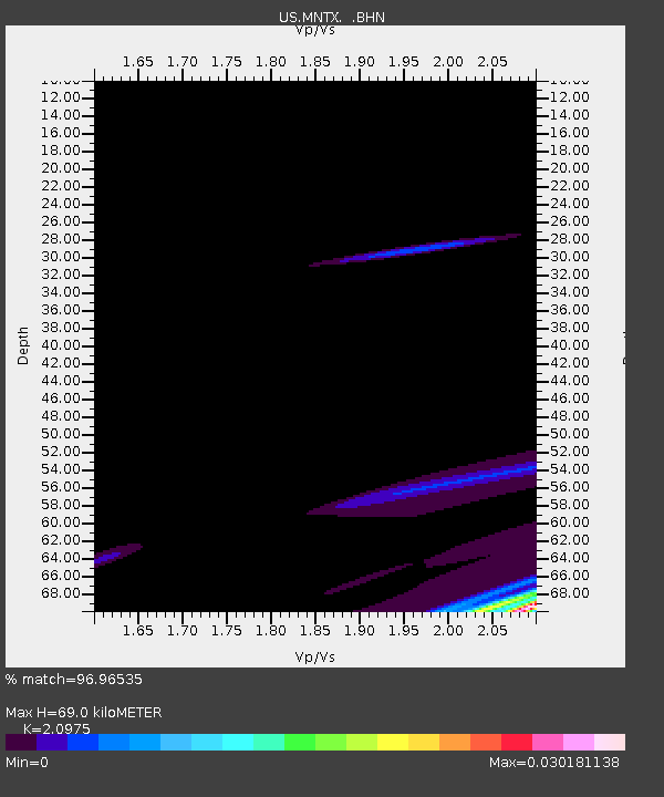
| Estimated Moho Depth: |
69.0 km |
| Estimated Crust Vp/Vs: |
2.10 |
| Assumed Crust Vp: |
6.361 km/s |
| Estimated Crust Vs: |
3.032 km/s |
| Estimated Crust Poisson's Ratio: |
0.35 |
|
| Radial Match: |
96.96535 % |
| Radial Bump: |
77 |
| Transverse Match: |
66.51102 % |
| Transverse Bump: |
239 |
| SOD ConfigId: |
2564 |
| Insert Time: |
2010-03-05 06:15:29.205 +0000 |
| GWidth: |
2.5 |
| Max Bumps: |
400 |
| Tol: |
0.001 |
|
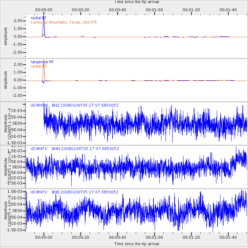
Signal To Noise
| Channel | StoN | STA | LTA |
| US:MNTX: :BHN:20080106T05:27:07.685005Z | 1.0575045 | 4.9752297E-10 | 4.704689E-10 |
| US:MNTX: :BHE:20080106T05:27:07.685005Z | 0.7954515 | 3.836083E-10 | 4.822523E-10 |
| US:MNTX: :BHZ:20080106T05:27:07.685005Z | 0.9556553 | 4.3264226E-10 | 4.5271792E-10 |
| Arrivals |
| Ps | 12 SECOND |
| PpPs | 33 SECOND |
| PsPs/PpSs | 45 SECOND |


