You are here: Home > Network List > AV - Alaska Volcano Observatory Stations List
> Station MAPS Pakushin Southeast, Makushin Volcano, Alaska > Earthquake Result Viewer
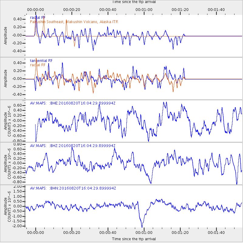
MAPS Pakushin Southeast, Makushin Volcano, Alaska - Earthquake Result Viewer
*The percent match for this event was below the threshold and hence no stack was calculated.
| Earthquake location: |
Off East Coast Of Honshu, Japan |
| Earthquake latitude/longitude: |
40.3/143.8 |
| Earthquake time(UTC): |
2016/08/20 (233) 15:58:04 GMT |
| Earthquake Depth: |
10 km |
| Earthquake Magnitude: |
6.0 MO |
| Earthquake Catalog/Contributor: |
NEIC PDE/NEIC ALERT |
|
| Network: |
AV Alaska Volcano Observatory |
| Station: |
MAPS Pakushin Southeast, Makushin Volcano, Alaska |
| Lat/Lon: |
53.81 N/166.94 W |
| Elevation: |
333 m |
|
| Distance: |
35.5 deg |
| Az: |
50.8 deg |
| Baz: |
268.074 deg |
| Ray Param: |
$rayparam |
*The percent match for this event was below the threshold and hence was not used in the summary stack. |
|
| Radial Match: |
48.873505 % |
| Radial Bump: |
293 |
| Transverse Match: |
51.127502 % |
| Transverse Bump: |
371 |
| SOD ConfigId: |
11737051 |
| Insert Time: |
2019-04-25 07:43:07.235 +0000 |
| GWidth: |
2.5 |
| Max Bumps: |
400 |
| Tol: |
0.001 |
|
Signal To Noise
| Channel | StoN | STA | LTA |
| AV:MAPS: :BHZ:20160820T16:04:29.899994Z | 0.9560816 | 1.7410748E-7 | 1.8210525E-7 |
| AV:MAPS: :BHN:20160820T16:04:29.899994Z | 0.5178349 | 1.7140427E-7 | 3.310018E-7 |
| AV:MAPS: :BHE:20160820T16:04:29.899994Z | 0.6936838 | 1.6034825E-7 | 2.3115467E-7 |
| Arrivals |
| Ps | |
| PpPs | |
| PsPs/PpSs | |


