You are here: Home > Network List > US - United States National Seismic Network Stations List
> Station MNTX Cornudas Mountains, Texas, USA > Earthquake Result Viewer
MNTX Cornudas Mountains, Texas, USA - Earthquake Result Viewer
| Earthquake location: |
Fiji Islands Region |
| Earthquake latitude/longitude: |
-15.3/-178.6 |
| Earthquake time(UTC): |
2005/12/13 (347) 03:16:06 GMT |
| Earthquake Depth: |
10 km |
| Earthquake Magnitude: |
6.1 MB, 6.8 MS, 6.7 MW, 6.7 MW |
| Earthquake Catalog/Contributor: |
WHDF/NEIC |
|
| Network: |
US United States National Seismic Network |
| Station: |
MNTX Cornudas Mountains, Texas, USA |
| Lat/Lon: |
31.70 N/105.38 W |
| Elevation: |
404 m |
|
| Distance: |
84.2 deg |
| Az: |
55.102 deg |
| Baz: |
248.23 deg |
| Ray Param: |
0.045653757 |
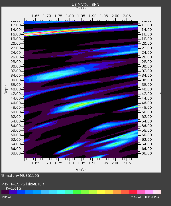
| Estimated Moho Depth: |
15.75 km |
| Estimated Crust Vp/Vs: |
1.62 |
| Assumed Crust Vp: |
6.361 km/s |
| Estimated Crust Vs: |
3.938 km/s |
| Estimated Crust Poisson's Ratio: |
0.19 |
|
| Radial Match: |
98.351105 % |
| Radial Bump: |
361 |
| Transverse Match: |
85.44997 % |
| Transverse Bump: |
398 |
| SOD ConfigId: |
110165 |
| Insert Time: |
2010-03-05 06:15:55.969 +0000 |
| GWidth: |
2.5 |
| Max Bumps: |
400 |
| Tol: |
0.001 |
|

Signal To Noise
| Channel | StoN | STA | LTA |
| US:MNTX: :BHN:20051213T03:28:06.312007Z | 1.2937968 | 2.1958452E-7 | 1.6972102E-7 |
| US:MNTX: :BHE:20051213T03:28:06.312007Z | 2.0966666 | 2.8088473E-7 | 1.3396728E-7 |
| US:MNTX: :BHZ:20051213T03:28:06.312007Z | 5.126991 | 8.7039354E-7 | 1.6976693E-7 |
| Arrivals |
| Ps | 1.6 SECOND |
| PpPs | 6.3 SECOND |
| PsPs/PpSs | 7.9 SECOND |


