You are here: Home > Network List > US - United States National Seismic Network Stations List
> Station MNTX Cornudas Mountains, Texas, USA > Earthquake Result Viewer
MNTX Cornudas Mountains, Texas, USA - Earthquake Result Viewer
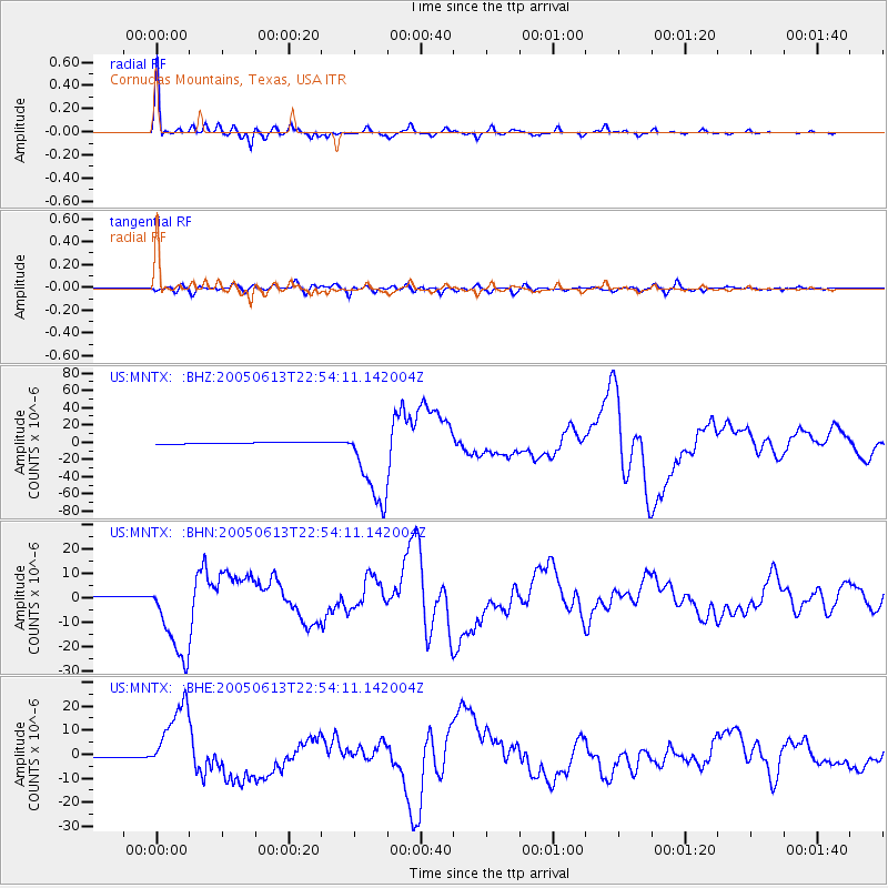
| Earthquake location: |
Northern Chile |
| Earthquake latitude/longitude: |
-20.0/-69.2 |
| Earthquake time(UTC): |
2005/06/13 (164) 22:44:33 GMT |
| Earthquake Depth: |
116 km |
| Earthquake Magnitude: |
6.8 MB, 7.8 MW, 7.8 MW |
| Earthquake Catalog/Contributor: |
WHDF/NEIC |
|
| Network: |
US United States National Seismic Network |
| Station: |
MNTX Cornudas Mountains, Texas, USA |
| Lat/Lon: |
31.70 N/105.38 W |
| Elevation: |
404 m |
|
| Distance: |
62.0 deg |
| Az: |
325.254 deg |
| Baz: |
141.035 deg |
| Ray Param: |
0.06017855 |
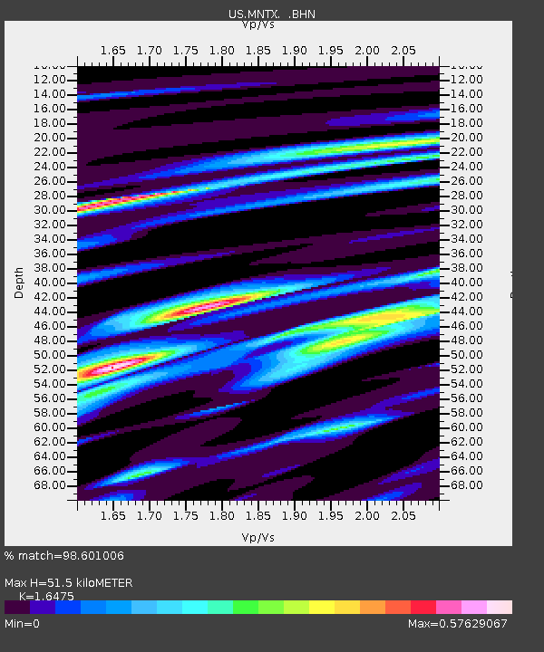
| Estimated Moho Depth: |
51.5 km |
| Estimated Crust Vp/Vs: |
1.65 |
| Assumed Crust Vp: |
6.361 km/s |
| Estimated Crust Vs: |
3.861 km/s |
| Estimated Crust Poisson's Ratio: |
0.21 |
|
| Radial Match: |
98.601006 % |
| Radial Bump: |
330 |
| Transverse Match: |
89.60653 % |
| Transverse Bump: |
400 |
| SOD ConfigId: |
110165 |
| Insert Time: |
2010-03-05 06:16:01.697 +0000 |
| GWidth: |
2.5 |
| Max Bumps: |
400 |
| Tol: |
0.001 |
|
Signal To Noise
| Channel | StoN | STA | LTA |
| US:MNTX: :BHN:20050613T22:54:11.142004Z | 37.950077 | 1.7392053E-5 | 4.5828764E-7 |
| US:MNTX: :BHE:20050613T22:54:11.142004Z | 54.856766 | 1.5148903E-5 | 2.7615377E-7 |
| US:MNTX: :BHZ:20050613T22:54:11.142004Z | 58.010826 | 4.9281804E-5 | 8.495277E-7 |
| Arrivals |
| Ps | 5.5 SECOND |
| PpPs | 20 SECOND |
| PsPs/PpSs | 26 SECOND |


