You are here: Home > Network List > US - United States National Seismic Network Stations List
> Station MNTX Cornudas Mountains, Texas, USA > Earthquake Result Viewer
MNTX Cornudas Mountains, Texas, USA - Earthquake Result Viewer
| Earthquake location: |
Northern Mid-Atlantic Ridge |
| Earthquake latitude/longitude: |
30.1/-42.6 |
| Earthquake time(UTC): |
2007/10/18 (291) 16:13:14 GMT |
| Earthquake Depth: |
10 km |
| Earthquake Magnitude: |
5.5 MB, 5.3 MS, 5.7 MW, 5.7 MW |
| Earthquake Catalog/Contributor: |
WHDF/NEIC |
|
| Network: |
US United States National Seismic Network |
| Station: |
MNTX Cornudas Mountains, Texas, USA |
| Lat/Lon: |
31.70 N/105.38 W |
| Elevation: |
404 m |
|
| Distance: |
53.2 deg |
| Az: |
288.817 deg |
| Baz: |
74.16 deg |
| Ray Param: |
0.066251546 |
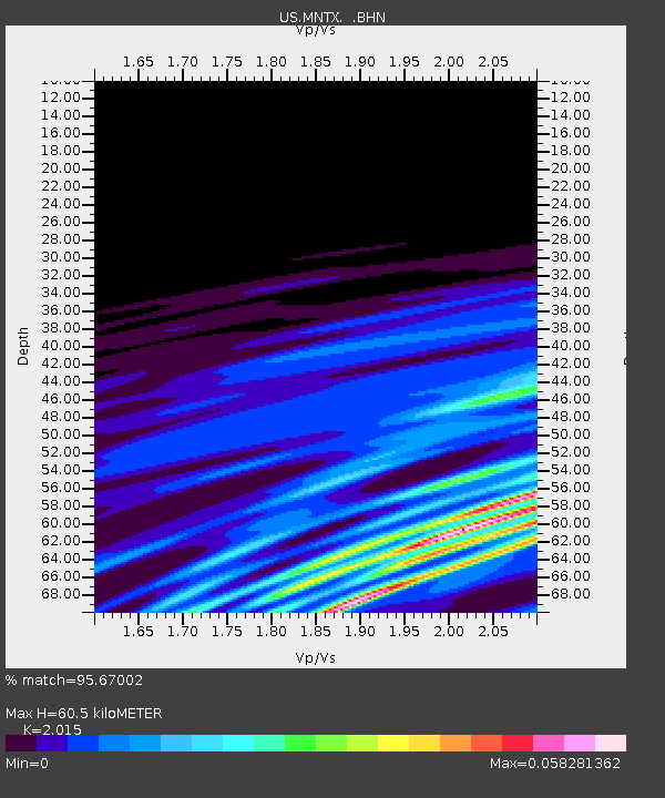
| Estimated Moho Depth: |
60.5 km |
| Estimated Crust Vp/Vs: |
2.02 |
| Assumed Crust Vp: |
6.361 km/s |
| Estimated Crust Vs: |
3.157 km/s |
| Estimated Crust Poisson's Ratio: |
0.34 |
|
| Radial Match: |
95.67002 % |
| Radial Bump: |
107 |
| Transverse Match: |
95.510765 % |
| Transverse Bump: |
122 |
| SOD ConfigId: |
2564 |
| Insert Time: |
2010-03-05 06:16:38.208 +0000 |
| GWidth: |
2.5 |
| Max Bumps: |
400 |
| Tol: |
0.001 |
|
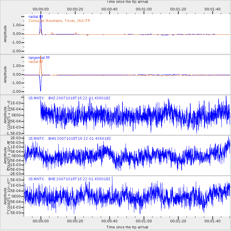
Signal To Noise
| Channel | StoN | STA | LTA |
| US:MNTX: :BHN:20071018T16:22:01.436018Z | 0.9761224 | 5.2471943E-10 | 5.3755495E-10 |
| US:MNTX: :BHE:20071018T16:22:01.436018Z | 0.8808359 | 4.68567E-10 | 5.3195726E-10 |
| US:MNTX: :BHZ:20071018T16:22:01.436018Z | 0.92310596 | 3.861125E-10 | 4.1827541E-10 |
| Arrivals |
| Ps | 10 SECOND |
| PpPs | 27 SECOND |
| PsPs/PpSs | 37 SECOND |


