You are here: Home > Network List > TA - USArray Transportable Network (new EarthScope stations) Stations List
> Station D25K Kavik River, AK, USA > Earthquake Result Viewer
D25K Kavik River, AK, USA - Earthquake Result Viewer
| Earthquake location: |
Off East Coast Of Honshu, Japan |
| Earthquake latitude/longitude: |
40.3/143.8 |
| Earthquake time(UTC): |
2016/08/20 (233) 15:58:04 GMT |
| Earthquake Depth: |
10 km |
| Earthquake Magnitude: |
6.0 MO |
| Earthquake Catalog/Contributor: |
NEIC PDE/NEIC ALERT |
|
| Network: |
TA USArray Transportable Network (new EarthScope stations) |
| Station: |
D25K Kavik River, AK, USA |
| Lat/Lon: |
69.32 N/146.38 W |
| Elevation: |
770 m |
|
| Distance: |
45.9 deg |
| Az: |
27.661 deg |
| Baz: |
268.624 deg |
| Ray Param: |
0.07096519 |
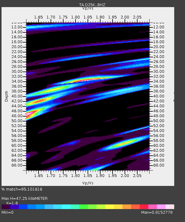
| Estimated Moho Depth: |
47.25 km |
| Estimated Crust Vp/Vs: |
1.60 |
| Assumed Crust Vp: |
6.378 km/s |
| Estimated Crust Vs: |
3.986 km/s |
| Estimated Crust Poisson's Ratio: |
0.18 |
|
| Radial Match: |
95.101616 % |
| Radial Bump: |
400 |
| Transverse Match: |
87.785645 % |
| Transverse Bump: |
400 |
| SOD ConfigId: |
11737051 |
| Insert Time: |
2019-04-25 07:49:44.136 +0000 |
| GWidth: |
2.5 |
| Max Bumps: |
400 |
| Tol: |
0.001 |
|
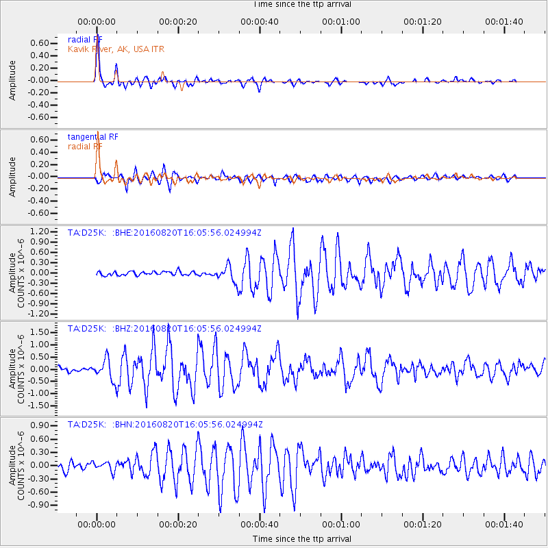
Signal To Noise
| Channel | StoN | STA | LTA |
| TA:D25K: :BHZ:20160820T16:05:56.024994Z | 6.123353 | 4.499514E-7 | 7.348121E-8 |
| TA:D25K: :BHN:20160820T16:05:56.024994Z | 1.1901104 | 1.0577715E-7 | 8.888011E-8 |
| TA:D25K: :BHE:20160820T16:05:56.024994Z | 4.2266736 | 2.3401387E-7 | 5.5365962E-8 |
| Arrivals |
| Ps | 4.8 SECOND |
| PpPs | 18 SECOND |
| PsPs/PpSs | 23 SECOND |


