You are here: Home > Network List > TA - USArray Transportable Network (new EarthScope stations) Stations List
> Station F21K Alatna River, AK, USA > Earthquake Result Viewer
F21K Alatna River, AK, USA - Earthquake Result Viewer
| Earthquake location: |
Off East Coast Of Honshu, Japan |
| Earthquake latitude/longitude: |
40.3/143.8 |
| Earthquake time(UTC): |
2016/08/20 (233) 15:58:04 GMT |
| Earthquake Depth: |
10 km |
| Earthquake Magnitude: |
6.0 MO |
| Earthquake Catalog/Contributor: |
NEIC PDE/NEIC ALERT |
|
| Network: |
TA USArray Transportable Network (new EarthScope stations) |
| Station: |
F21K Alatna River, AK, USA |
| Lat/Lon: |
67.22 N/153.48 W |
| Elevation: |
597 m |
|
| Distance: |
43.1 deg |
| Az: |
30.415 deg |
| Baz: |
263.989 deg |
| Ray Param: |
0.07274151 |
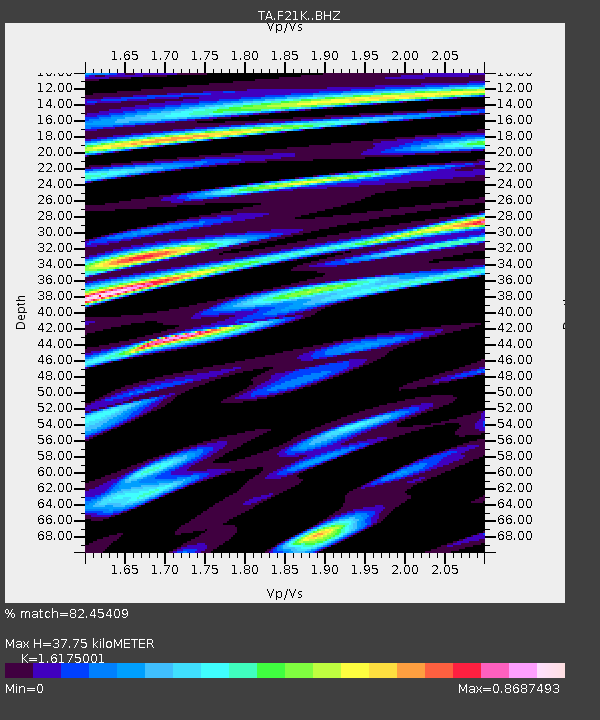
| Estimated Moho Depth: |
37.75 km |
| Estimated Crust Vp/Vs: |
1.62 |
| Assumed Crust Vp: |
6.455 km/s |
| Estimated Crust Vs: |
3.991 km/s |
| Estimated Crust Poisson's Ratio: |
0.19 |
|
| Radial Match: |
82.45409 % |
| Radial Bump: |
400 |
| Transverse Match: |
67.84258 % |
| Transverse Bump: |
400 |
| SOD ConfigId: |
11737051 |
| Insert Time: |
2019-04-25 07:49:48.762 +0000 |
| GWidth: |
2.5 |
| Max Bumps: |
400 |
| Tol: |
0.001 |
|
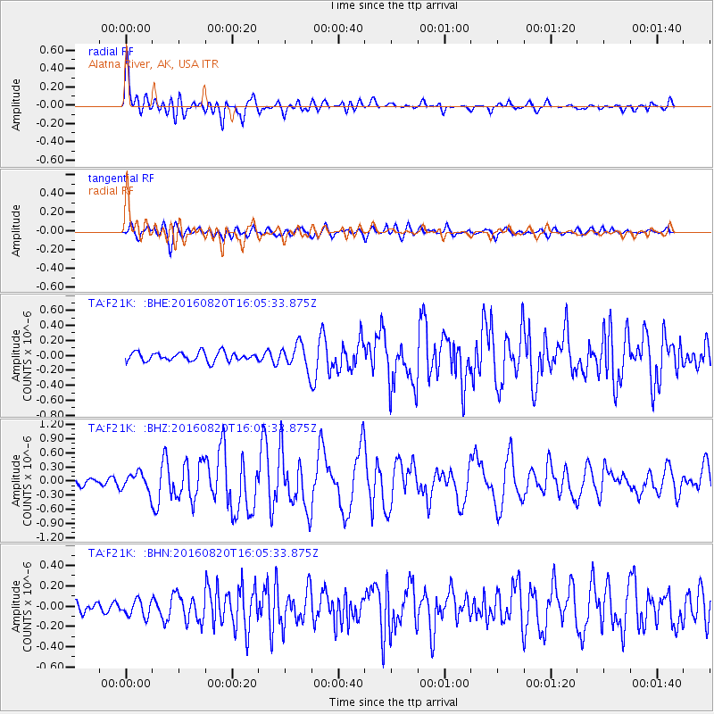
Signal To Noise
| Channel | StoN | STA | LTA |
| TA:F21K: :BHZ:20160820T16:05:33.875Z | 2.307629 | 1.9653021E-7 | 8.5165425E-8 |
| TA:F21K: :BHN:20160820T16:05:33.875Z | 1.4888239 | 8.245374E-8 | 5.5381793E-8 |
| TA:F21K: :BHE:20160820T16:05:33.875Z | 2.6338153 | 1.5731875E-7 | 5.973037E-8 |
| Arrivals |
| Ps | 3.9 SECOND |
| PpPs | 14 SECOND |
| PsPs/PpSs | 18 SECOND |


