You are here: Home > Network List > TA - USArray Transportable Network (new EarthScope stations) Stations List
> Station G22K Bettles, AK, USA > Earthquake Result Viewer
G22K Bettles, AK, USA - Earthquake Result Viewer
| Earthquake location: |
Off East Coast Of Honshu, Japan |
| Earthquake latitude/longitude: |
40.3/143.8 |
| Earthquake time(UTC): |
2016/08/20 (233) 15:58:04 GMT |
| Earthquake Depth: |
10 km |
| Earthquake Magnitude: |
6.0 MO |
| Earthquake Catalog/Contributor: |
NEIC PDE/NEIC ALERT |
|
| Network: |
TA USArray Transportable Network (new EarthScope stations) |
| Station: |
G22K Bettles, AK, USA |
| Lat/Lon: |
66.92 N/151.51 W |
| Elevation: |
205 m |
|
| Distance: |
43.9 deg |
| Az: |
30.949 deg |
| Baz: |
266.193 deg |
| Ray Param: |
0.07225844 |
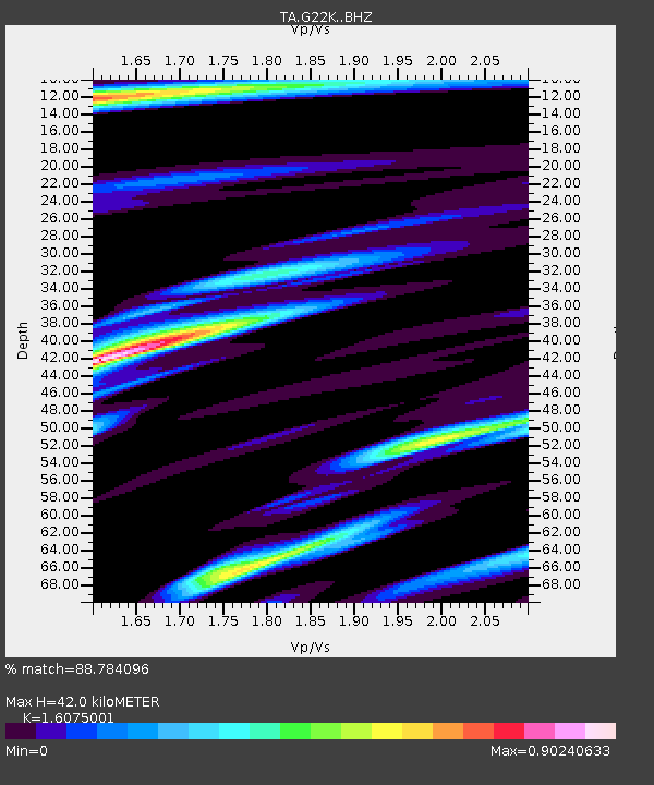
| Estimated Moho Depth: |
42.0 km |
| Estimated Crust Vp/Vs: |
1.61 |
| Assumed Crust Vp: |
6.577 km/s |
| Estimated Crust Vs: |
4.091 km/s |
| Estimated Crust Poisson's Ratio: |
0.18 |
|
| Radial Match: |
88.784096 % |
| Radial Bump: |
400 |
| Transverse Match: |
79.0606 % |
| Transverse Bump: |
400 |
| SOD ConfigId: |
11737051 |
| Insert Time: |
2019-04-25 07:49:53.303 +0000 |
| GWidth: |
2.5 |
| Max Bumps: |
400 |
| Tol: |
0.001 |
|

Signal To Noise
| Channel | StoN | STA | LTA |
| TA:G22K: :BHZ:20160820T16:05:39.875Z | 2.9836628 | 2.9047425E-7 | 9.735491E-8 |
| TA:G22K: :BHN:20160820T16:05:39.875Z | 0.76335394 | 8.899879E-8 | 1.1658915E-7 |
| TA:G22K: :BHE:20160820T16:05:39.875Z | 2.52184 | 2.3333097E-7 | 9.25241E-8 |
| Arrivals |
| Ps | 4.2 SECOND |
| PpPs | 15 SECOND |
| PsPs/PpSs | 20 SECOND |


