You are here: Home > Network List > TA - USArray Transportable Network (new EarthScope stations) Stations List
> Station I23K Minto, Yukon-Koyukuk, AK, USA > Earthquake Result Viewer
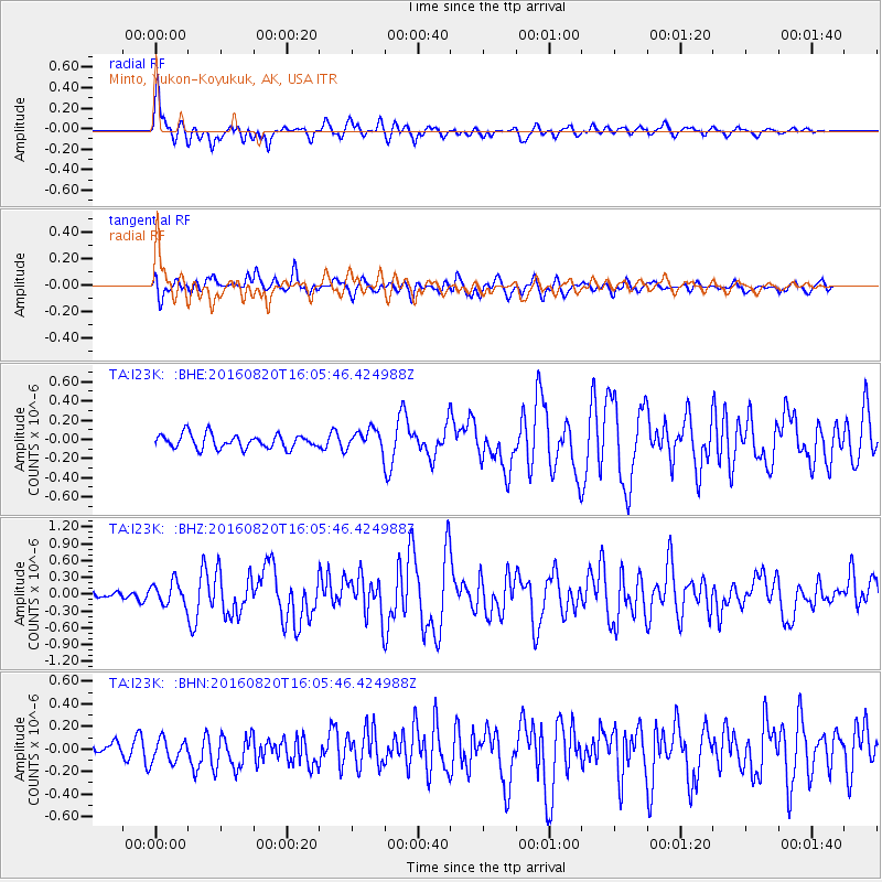
I23K Minto, Yukon-Koyukuk, AK, USA - Earthquake Result Viewer
*The percent match for this event was below the threshold and hence no stack was calculated.
| Earthquake location: |
Off East Coast Of Honshu, Japan |
| Earthquake latitude/longitude: |
40.3/143.8 |
| Earthquake time(UTC): |
2016/08/20 (233) 15:58:04 GMT |
| Earthquake Depth: |
10 km |
| Earthquake Magnitude: |
6.0 MO |
| Earthquake Catalog/Contributor: |
NEIC PDE/NEIC ALERT |
|
| Network: |
TA USArray Transportable Network (new EarthScope stations) |
| Station: |
I23K Minto, Yukon-Koyukuk, AK, USA |
| Lat/Lon: |
65.15 N/149.36 W |
| Elevation: |
149 m |
|
| Distance: |
44.7 deg |
| Az: |
33.539 deg |
| Baz: |
270.008 deg |
| Ray Param: |
$rayparam |
*The percent match for this event was below the threshold and hence was not used in the summary stack. |
|
| Radial Match: |
78.35811 % |
| Radial Bump: |
400 |
| Transverse Match: |
71.41821 % |
| Transverse Bump: |
400 |
| SOD ConfigId: |
11737051 |
| Insert Time: |
2019-04-25 07:50:01.945 +0000 |
| GWidth: |
2.5 |
| Max Bumps: |
400 |
| Tol: |
0.001 |
|
Signal To Noise
| Channel | StoN | STA | LTA |
| TA:I23K: :BHZ:20160820T16:05:46.424988Z | 3.004191 | 2.0397914E-7 | 6.789819E-8 |
| TA:I23K: :BHN:20160820T16:05:46.424988Z | 1.1107897 | 1.01386895E-7 | 9.1274615E-8 |
| TA:I23K: :BHE:20160820T16:05:46.424988Z | 1.3856432 | 1.0154321E-7 | 7.328236E-8 |
| Arrivals |
| Ps | |
| PpPs | |
| PsPs/PpSs | |


