You are here: Home > Network List > TA - USArray Transportable Network (new EarthScope stations) Stations List
> Station P17K Kvichak River, AK, USA > Earthquake Result Viewer
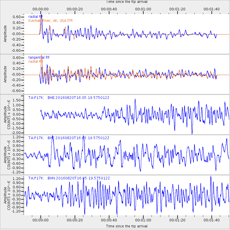
P17K Kvichak River, AK, USA - Earthquake Result Viewer
*The percent match for this event was below the threshold and hence no stack was calculated.
| Earthquake location: |
Off East Coast Of Honshu, Japan |
| Earthquake latitude/longitude: |
40.3/143.8 |
| Earthquake time(UTC): |
2016/08/20 (233) 15:58:04 GMT |
| Earthquake Depth: |
10 km |
| Earthquake Magnitude: |
6.0 MO |
| Earthquake Catalog/Contributor: |
NEIC PDE/NEIC ALERT |
|
| Network: |
TA USArray Transportable Network (new EarthScope stations) |
| Station: |
P17K Kvichak River, AK, USA |
| Lat/Lon: |
59.20 N/156.44 W |
| Elevation: |
91 m |
|
| Distance: |
41.4 deg |
| Az: |
42.287 deg |
| Baz: |
270.148 deg |
| Ray Param: |
$rayparam |
*The percent match for this event was below the threshold and hence was not used in the summary stack. |
|
| Radial Match: |
76.54183 % |
| Radial Bump: |
400 |
| Transverse Match: |
71.58876 % |
| Transverse Bump: |
400 |
| SOD ConfigId: |
11737051 |
| Insert Time: |
2019-04-25 07:50:17.174 +0000 |
| GWidth: |
2.5 |
| Max Bumps: |
400 |
| Tol: |
0.001 |
|
Signal To Noise
| Channel | StoN | STA | LTA |
| TA:P17K: :BHZ:20160820T16:05:19.575012Z | 2.1964839 | 1.9974293E-7 | 9.093758E-8 |
| TA:P17K: :BHN:20160820T16:05:19.575012Z | 0.77374876 | 1.9713477E-7 | 2.5477877E-7 |
| TA:P17K: :BHE:20160820T16:05:19.575012Z | 0.9461277 | 2.018764E-7 | 2.133712E-7 |
| Arrivals |
| Ps | |
| PpPs | |
| PsPs/PpSs | |


