You are here: Home > Network List > US - United States National Seismic Network Stations List
> Station EGMT Eagleton, Montana, USA > Earthquake Result Viewer
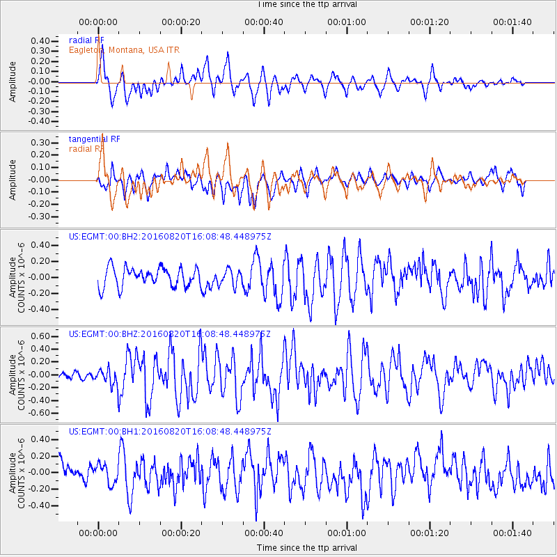
EGMT Eagleton, Montana, USA - Earthquake Result Viewer
*The percent match for this event was below the threshold and hence no stack was calculated.
| Earthquake location: |
Off East Coast Of Honshu, Japan |
| Earthquake latitude/longitude: |
40.3/143.8 |
| Earthquake time(UTC): |
2016/08/20 (233) 15:58:04 GMT |
| Earthquake Depth: |
10 km |
| Earthquake Magnitude: |
6.0 MO |
| Earthquake Catalog/Contributor: |
NEIC PDE/NEIC ALERT |
|
| Network: |
US United States National Seismic Network |
| Station: |
EGMT Eagleton, Montana, USA |
| Lat/Lon: |
48.02 N/109.75 W |
| Elevation: |
1055 m |
|
| Distance: |
70.6 deg |
| Az: |
43.024 deg |
| Baz: |
308.974 deg |
| Ray Param: |
$rayparam |
*The percent match for this event was below the threshold and hence was not used in the summary stack. |
|
| Radial Match: |
64.07268 % |
| Radial Bump: |
400 |
| Transverse Match: |
52.39194 % |
| Transverse Bump: |
400 |
| SOD ConfigId: |
11737051 |
| Insert Time: |
2019-04-25 07:50:51.066 +0000 |
| GWidth: |
2.5 |
| Max Bumps: |
400 |
| Tol: |
0.001 |
|
Signal To Noise
| Channel | StoN | STA | LTA |
| US:EGMT:00:BHZ:20160820T16:08:48.448975Z | 1.9062359 | 1.3648514E-7 | 7.1599295E-8 |
| US:EGMT:00:BH1:20160820T16:08:48.448975Z | 1.0325365 | 1.1769329E-7 | 1.1398463E-7 |
| US:EGMT:00:BH2:20160820T16:08:48.448975Z | 0.8541349 | 1.0008431E-7 | 1.1717623E-7 |
| Arrivals |
| Ps | |
| PpPs | |
| PsPs/PpSs | |


