You are here: Home > Network List > EC - Ecuador Seismic Network Stations List
> Station IMBA OVIMBA_S > Earthquake Result Viewer
IMBA OVIMBA_S - Earthquake Result Viewer
| Earthquake location: |
South Georgia Island Region |
| Earthquake latitude/longitude: |
-55.3/-31.8 |
| Earthquake time(UTC): |
2016/08/21 (234) 03:45:23 GMT |
| Earthquake Depth: |
10 km |
| Earthquake Magnitude: |
6.4 MWP |
| Earthquake Catalog/Contributor: |
NEIC PDE/NEIC COMCAT |
|
| Network: |
EC Ecuador Seismic Network |
| Station: |
IMBA OVIMBA_S |
| Lat/Lon: |
0.28 N/78.20 W |
| Elevation: |
3404 m |
|
| Distance: |
67.0 deg |
| Az: |
308.081 deg |
| Baz: |
153.231 deg |
| Ray Param: |
0.057226077 |
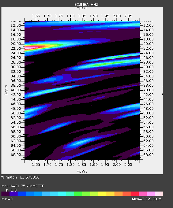
| Estimated Moho Depth: |
21.75 km |
| Estimated Crust Vp/Vs: |
1.60 |
| Assumed Crust Vp: |
6.472 km/s |
| Estimated Crust Vs: |
4.045 km/s |
| Estimated Crust Poisson's Ratio: |
0.18 |
|
| Radial Match: |
81.575356 % |
| Radial Bump: |
400 |
| Transverse Match: |
75.49293 % |
| Transverse Bump: |
400 |
| SOD ConfigId: |
11737051 |
| Insert Time: |
2019-04-25 07:54:15.726 +0000 |
| GWidth: |
2.5 |
| Max Bumps: |
400 |
| Tol: |
0.001 |
|

Signal To Noise
| Channel | StoN | STA | LTA |
| EC:IMBA: :HHZ:20160821T03:55:45.628Z | 16.65848 | 4.03444E-6 | 2.4218534E-7 |
| EC:IMBA: :HHN:20160821T03:55:45.628Z | 1.3879567 | 1.1266986E-6 | 8.117678E-7 |
| EC:IMBA: :HHE:20160821T03:55:45.628Z | 1.844649 | 9.263238E-7 | 5.021681E-7 |
| Arrivals |
| Ps | 2.1 SECOND |
| PpPs | 8.4 SECOND |
| PsPs/PpSs | 10 SECOND |


