You are here: Home > Network List > N4 - Central and EAstern US Network Stations List
> Station 061Z Ochoppi, FL, USA > Earthquake Result Viewer
061Z Ochoppi, FL, USA - Earthquake Result Viewer
| Earthquake location: |
South Georgia Island Region |
| Earthquake latitude/longitude: |
-55.3/-31.8 |
| Earthquake time(UTC): |
2016/08/21 (234) 03:45:23 GMT |
| Earthquake Depth: |
10 km |
| Earthquake Magnitude: |
6.4 MWP |
| Earthquake Catalog/Contributor: |
NEIC PDE/NEIC COMCAT |
|
| Network: |
N4 Central and EAstern US Network |
| Station: |
061Z Ochoppi, FL, USA |
| Lat/Lon: |
25.87 N/80.91 W |
| Elevation: |
9.0 m |
|
| Distance: |
91.1 deg |
| Az: |
317.027 deg |
| Baz: |
154.348 deg |
| Ray Param: |
0.04162831 |
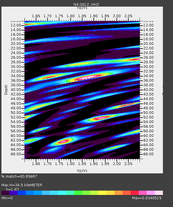
| Estimated Moho Depth: |
34.5 km |
| Estimated Crust Vp/Vs: |
1.87 |
| Assumed Crust Vp: |
5.78 km/s |
| Estimated Crust Vs: |
3.091 km/s |
| Estimated Crust Poisson's Ratio: |
0.30 |
|
| Radial Match: |
80.95697 % |
| Radial Bump: |
400 |
| Transverse Match: |
63.375107 % |
| Transverse Bump: |
400 |
| SOD ConfigId: |
11737051 |
| Insert Time: |
2019-04-25 07:54:47.647 +0000 |
| GWidth: |
2.5 |
| Max Bumps: |
400 |
| Tol: |
0.001 |
|

Signal To Noise
| Channel | StoN | STA | LTA |
| N4:061Z: :HHZ:20160821T03:57:56.709971Z | 19.787165 | 1.9992224E-6 | 1.0103631E-7 |
| N4:061Z: :HHN:20160821T03:57:56.709971Z | 5.5102177 | 6.531364E-7 | 1.18531865E-7 |
| N4:061Z: :HHE:20160821T03:57:56.709971Z | 1.8601444 | 2.3952046E-7 | 1.2876444E-7 |
| Arrivals |
| Ps | 5.3 SECOND |
| PpPs | 17 SECOND |
| PsPs/PpSs | 22 SECOND |


