You are here: Home > Network List > NR - NARS Array Stations List
> Station NE212 Kaudwane > Earthquake Result Viewer
NE212 Kaudwane - Earthquake Result Viewer
| Earthquake location: |
South Georgia Island Region |
| Earthquake latitude/longitude: |
-55.3/-31.8 |
| Earthquake time(UTC): |
2016/08/21 (234) 03:45:23 GMT |
| Earthquake Depth: |
10 km |
| Earthquake Magnitude: |
6.4 MWP |
| Earthquake Catalog/Contributor: |
NEIC PDE/NEIC COMCAT |
|
| Network: |
NR NARS Array |
| Station: |
NE212 Kaudwane |
| Lat/Lon: |
23.38 S/24.66 E |
| Elevation: |
1038 m |
|
| Distance: |
52.1 deg |
| Az: |
75.985 deg |
| Baz: |
217.17 deg |
| Ray Param: |
0.06698419 |
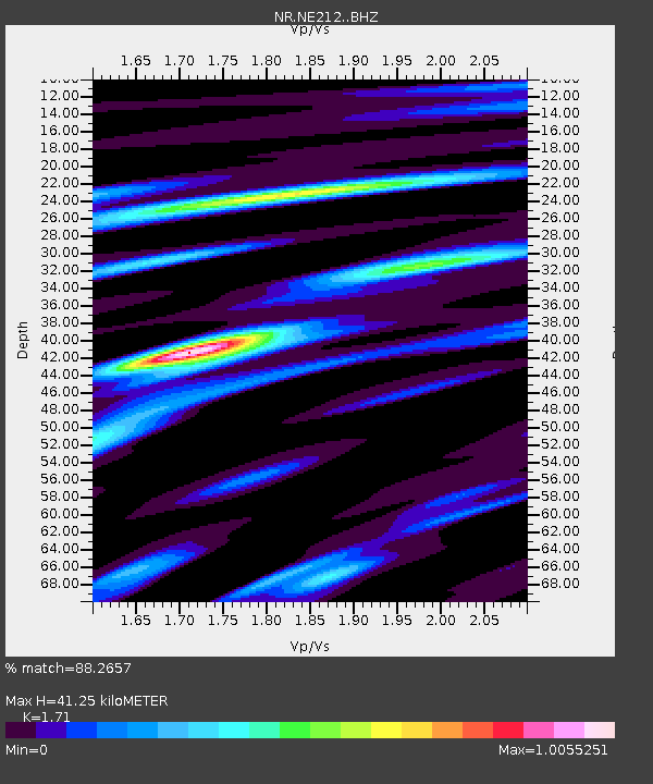
| Estimated Moho Depth: |
41.25 km |
| Estimated Crust Vp/Vs: |
1.71 |
| Assumed Crust Vp: |
6.459 km/s |
| Estimated Crust Vs: |
3.777 km/s |
| Estimated Crust Poisson's Ratio: |
0.24 |
|
| Radial Match: |
88.2657 % |
| Radial Bump: |
331 |
| Transverse Match: |
73.900665 % |
| Transverse Bump: |
400 |
| SOD ConfigId: |
11737051 |
| Insert Time: |
2019-04-25 07:55:04.572 +0000 |
| GWidth: |
2.5 |
| Max Bumps: |
400 |
| Tol: |
0.001 |
|

Signal To Noise
| Channel | StoN | STA | LTA |
| NR:NE212: :BHZ:20160821T03:54:02.805002Z | 8.337236 | 1.965813E-6 | 2.3578713E-7 |
| NR:NE212: :BHN:20160821T03:54:02.805002Z | 3.6159728 | 7.3510324E-7 | 2.0329337E-7 |
| NR:NE212: :BHE:20160821T03:54:02.805002Z | 2.6724308 | 6.9020564E-7 | 2.5826884E-7 |
| Arrivals |
| Ps | 4.8 SECOND |
| PpPs | 16 SECOND |
| PsPs/PpSs | 21 SECOND |


