You are here: Home > Network List > OV - Observatorio Vulcanolżgico y Sismolżgico de Costa Rica Stations List
> Station RIFO RIO FRIO, Sarapiqui, Heredia > Earthquake Result Viewer
RIFO RIO FRIO, Sarapiqui, Heredia - Earthquake Result Viewer
| Earthquake location: |
South Georgia Island Region |
| Earthquake latitude/longitude: |
-55.3/-31.8 |
| Earthquake time(UTC): |
2016/08/21 (234) 03:45:23 GMT |
| Earthquake Depth: |
10 km |
| Earthquake Magnitude: |
6.4 MWP |
| Earthquake Catalog/Contributor: |
NEIC PDE/NEIC COMCAT |
|
| Network: |
OV Observatorio Vulcanolżgico y Sismolżgico de Costa Rica |
| Station: |
RIFO RIO FRIO, Sarapiqui, Heredia |
| Lat/Lon: |
10.32 N/83.92 W |
| Elevation: |
139 m |
|
| Distance: |
78.5 deg |
| Az: |
307.52 deg |
| Baz: |
152.536 deg |
| Ray Param: |
0.049601275 |
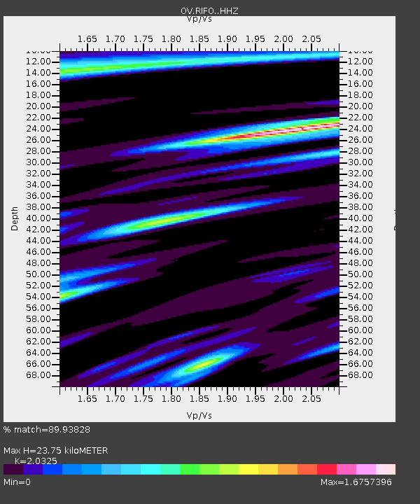
| Estimated Moho Depth: |
23.75 km |
| Estimated Crust Vp/Vs: |
2.03 |
| Assumed Crust Vp: |
5.989 km/s |
| Estimated Crust Vs: |
2.947 km/s |
| Estimated Crust Poisson's Ratio: |
0.34 |
|
| Radial Match: |
89.93828 % |
| Radial Bump: |
400 |
| Transverse Match: |
87.174545 % |
| Transverse Bump: |
400 |
| SOD ConfigId: |
11737051 |
| Insert Time: |
2019-04-25 07:55:43.430 +0000 |
| GWidth: |
2.5 |
| Max Bumps: |
400 |
| Tol: |
0.001 |
|

Signal To Noise
| Channel | StoN | STA | LTA |
| OV:RIFO: :HHZ:20160821T03:56:53.578013Z | 25.03556 | 5.641355E-6 | 2.2533368E-7 |
| OV:RIFO: :HHN:20160821T03:56:53.578013Z | 10.336913 | 2.1141957E-6 | 2.0452873E-7 |
| OV:RIFO: :HHE:20160821T03:56:53.578013Z | 2.7977657 | 1.0653571E-6 | 3.8078852E-7 |
| Arrivals |
| Ps | 4.2 SECOND |
| PpPs | 12 SECOND |
| PsPs/PpSs | 16 SECOND |


