You are here: Home > Network List > PR - Puerto Rico Seismic Network (PRSN) & Puerto Rico Strong Motion Program (PRSMP) Stations List
> Station STVI ST. THOMAS VI (4132) > Earthquake Result Viewer
STVI ST. THOMAS VI (4132) - Earthquake Result Viewer
| Earthquake location: |
South Georgia Island Region |
| Earthquake latitude/longitude: |
-55.3/-31.8 |
| Earthquake time(UTC): |
2016/08/21 (234) 03:45:23 GMT |
| Earthquake Depth: |
10 km |
| Earthquake Magnitude: |
6.4 MWP |
| Earthquake Catalog/Contributor: |
NEIC PDE/NEIC COMCAT |
|
| Network: |
PR Puerto Rico Seismic Network (PRSN) & Puerto Rico Strong Motion Program (PRSMP) |
| Station: |
STVI ST. THOMAS VI (4132) |
| Lat/Lon: |
18.35 N/64.96 W |
| Elevation: |
103 m |
|
| Distance: |
78.6 deg |
| Az: |
327.949 deg |
| Baz: |
161.355 deg |
| Ray Param: |
0.04954538 |
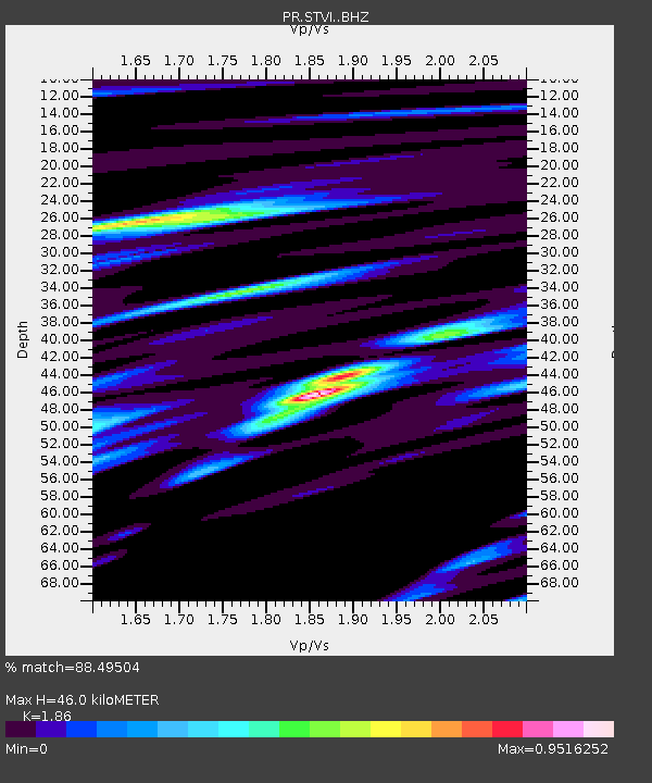
| Estimated Moho Depth: |
46.0 km |
| Estimated Crust Vp/Vs: |
1.86 |
| Assumed Crust Vp: |
5.14 km/s |
| Estimated Crust Vs: |
2.763 km/s |
| Estimated Crust Poisson's Ratio: |
0.30 |
|
| Radial Match: |
88.49504 % |
| Radial Bump: |
400 |
| Transverse Match: |
80.970535 % |
| Transverse Bump: |
400 |
| SOD ConfigId: |
11737051 |
| Insert Time: |
2019-04-25 07:56:16.012 +0000 |
| GWidth: |
2.5 |
| Max Bumps: |
400 |
| Tol: |
0.001 |
|

Signal To Noise
| Channel | StoN | STA | LTA |
| PR:STVI: :BHZ:20160821T03:56:54.029978Z | 20.335207 | 2.0787493E-6 | 1.02224156E-7 |
| PR:STVI: :BHN:20160821T03:56:54.029978Z | 5.278826 | 7.2914077E-7 | 1.3812556E-7 |
| PR:STVI: :BHE:20160821T03:56:54.029978Z | 1.0409529 | 1.8623753E-7 | 1.7891061E-7 |
| Arrivals |
| Ps | 7.8 SECOND |
| PpPs | 25 SECOND |
| PsPs/PpSs | 33 SECOND |


