You are here: Home > Network List > US - United States National Seismic Network Stations List
> Station MNTX Cornudas Mountains, Texas, USA > Earthquake Result Viewer
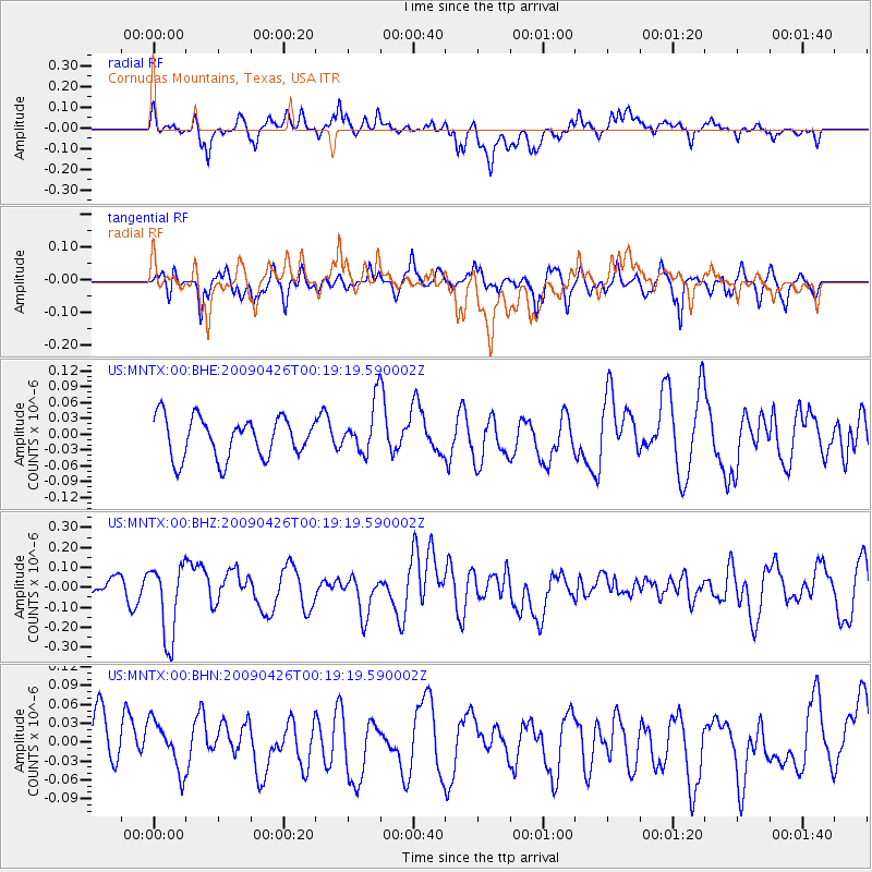
MNTX Cornudas Mountains, Texas, USA - Earthquake Result Viewer
*The percent match for this event was below the threshold and hence no stack was calculated.
| Earthquake location: |
Kermadec Islands, New Zealand |
| Earthquake latitude/longitude: |
-30.3/-178.6 |
| Earthquake time(UTC): |
2009/04/26 (116) 00:06:53 GMT |
| Earthquake Depth: |
132 km |
| Earthquake Magnitude: |
5.5 MB, 6.1 MW, 6.1 MW |
| Earthquake Catalog/Contributor: |
WHDF/NEIC |
|
| Network: |
US United States National Seismic Network |
| Station: |
MNTX Cornudas Mountains, Texas, USA |
| Lat/Lon: |
31.70 N/105.38 W |
| Elevation: |
404 m |
|
| Distance: |
92.8 deg |
| Az: |
54.787 deg |
| Baz: |
235.993 deg |
| Ray Param: |
$rayparam |
*The percent match for this event was below the threshold and hence was not used in the summary stack. |
|
| Radial Match: |
68.56197 % |
| Radial Bump: |
400 |
| Transverse Match: |
56.760273 % |
| Transverse Bump: |
392 |
| SOD ConfigId: |
2760 |
| Insert Time: |
2010-03-05 06:18:17.296 +0000 |
| GWidth: |
2.5 |
| Max Bumps: |
400 |
| Tol: |
0.001 |
|
Signal To Noise
| Channel | StoN | STA | LTA |
| US:MNTX:00:BHZ:20090426T00:19:19.590002Z | 3.8129303 | 1.8596069E-7 | 4.8771067E-8 |
| US:MNTX:00:BHN:20090426T00:19:19.590002Z | 0.7983877 | 3.8764682E-8 | 4.85537E-8 |
| US:MNTX:00:BHE:20090426T00:19:19.590002Z | 1.24901 | 4.748071E-8 | 3.8014676E-8 |
| Arrivals |
| Ps | |
| PpPs | |
| PsPs/PpSs | |


