You are here: Home > Network List > US - United States National Seismic Network Stations List
> Station MNTX Cornudas Mountains, Texas, USA > Earthquake Result Viewer
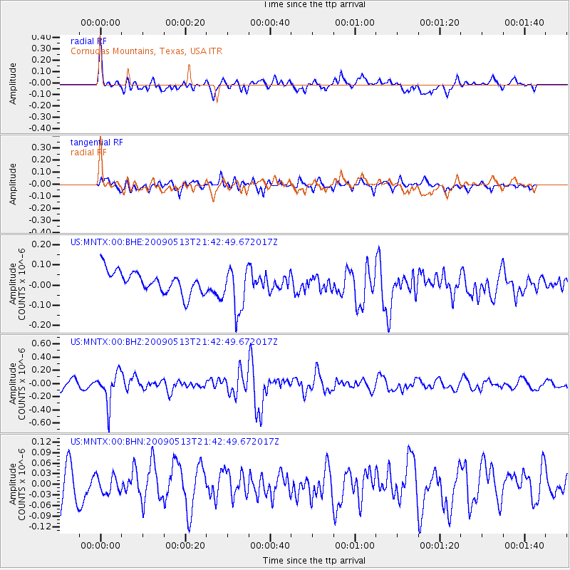
MNTX Cornudas Mountains, Texas, USA - Earthquake Result Viewer
*The percent match for this event was below the threshold and hence no stack was calculated.
| Earthquake location: |
Tonga Islands |
| Earthquake latitude/longitude: |
-15.8/-173.5 |
| Earthquake time(UTC): |
2009/05/13 (133) 21:31:17 GMT |
| Earthquake Depth: |
85 km |
| Earthquake Magnitude: |
5.8 MW, 5.3 MB, 5.8 MW |
| Earthquake Catalog/Contributor: |
WHDF/NEIC |
|
| Network: |
US United States National Seismic Network |
| Station: |
MNTX Cornudas Mountains, Texas, USA |
| Lat/Lon: |
31.70 N/105.38 W |
| Elevation: |
404 m |
|
| Distance: |
80.5 deg |
| Az: |
53.314 deg |
| Baz: |
244.945 deg |
| Ray Param: |
$rayparam |
*The percent match for this event was below the threshold and hence was not used in the summary stack. |
|
| Radial Match: |
53.35484 % |
| Radial Bump: |
400 |
| Transverse Match: |
56.178616 % |
| Transverse Bump: |
400 |
| SOD ConfigId: |
2760 |
| Insert Time: |
2010-03-05 06:18:17.995 +0000 |
| GWidth: |
2.5 |
| Max Bumps: |
400 |
| Tol: |
0.001 |
|
Signal To Noise
| Channel | StoN | STA | LTA |
| US:MNTX:00:BHZ:20090513T21:42:49.672017Z | 3.956695 | 2.389768E-7 | 6.039809E-8 |
| US:MNTX:00:BHN:20090513T21:42:49.672017Z | 0.46539786 | 3.0118493E-8 | 6.471558E-8 |
| US:MNTX:00:BHE:20090513T21:42:49.672017Z | 2.0874443 | 1.1170839E-7 | 5.351443E-8 |
| Arrivals |
| Ps | |
| PpPs | |
| PsPs/PpSs | |


