You are here: Home > Network List > WI - West Indies IPGP Network Stations List
> Station MPOM Morne Pois, Sainte-Anne, Martinique > Earthquake Result Viewer
MPOM Morne Pois, Sainte-Anne, Martinique - Earthquake Result Viewer
| Earthquake location: |
South Georgia Island Region |
| Earthquake latitude/longitude: |
-55.3/-31.8 |
| Earthquake time(UTC): |
2016/08/21 (234) 03:45:23 GMT |
| Earthquake Depth: |
10 km |
| Earthquake Magnitude: |
6.4 MWP |
| Earthquake Catalog/Contributor: |
NEIC PDE/NEIC COMCAT |
|
| Network: |
WI West Indies IPGP Network |
| Station: |
MPOM Morne Pois, Sainte-Anne, Martinique |
| Lat/Lon: |
14.45 N/60.86 W |
| Elevation: |
50 m |
|
| Distance: |
73.7 deg |
| Az: |
330.594 deg |
| Baz: |
163.142 deg |
| Ray Param: |
0.052843265 |
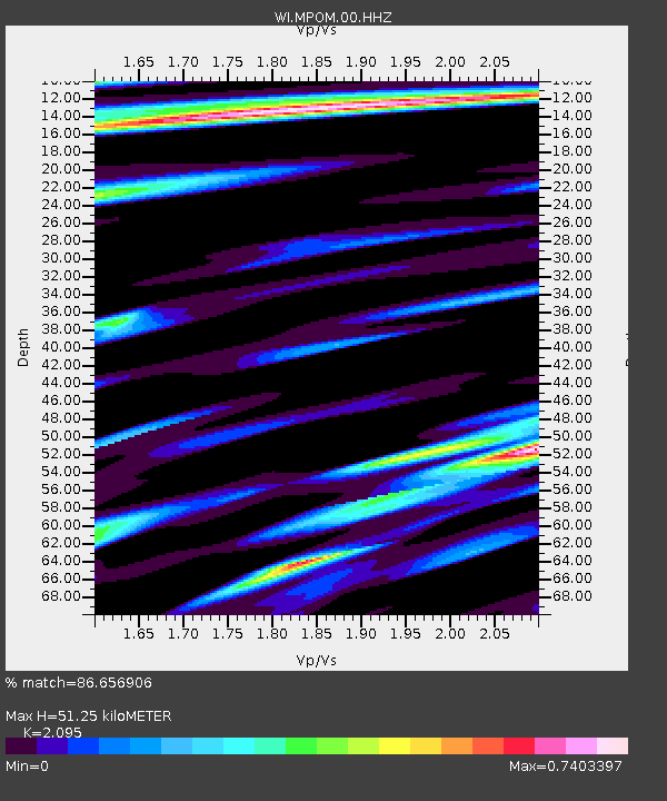
| Estimated Moho Depth: |
51.25 km |
| Estimated Crust Vp/Vs: |
2.10 |
| Assumed Crust Vp: |
5.88 km/s |
| Estimated Crust Vs: |
2.807 km/s |
| Estimated Crust Poisson's Ratio: |
0.35 |
|
| Radial Match: |
86.656906 % |
| Radial Bump: |
394 |
| Transverse Match: |
69.39969 % |
| Transverse Bump: |
400 |
| SOD ConfigId: |
11737051 |
| Insert Time: |
2019-04-25 07:56:55.394 +0000 |
| GWidth: |
2.5 |
| Max Bumps: |
400 |
| Tol: |
0.001 |
|

Signal To Noise
| Channel | StoN | STA | LTA |
| WI:MPOM:00:HHZ:20160821T03:56:26.21998Z | 9.70809 | 1.7379125E-6 | 1.7901694E-7 |
| WI:MPOM:00:HHN:20160821T03:56:26.21998Z | 4.396182 | 7.677248E-7 | 1.7463445E-7 |
| WI:MPOM:00:HHE:20160821T03:56:26.21998Z | 2.5017164 | 4.127307E-7 | 1.6497903E-7 |
| Arrivals |
| Ps | 9.8 SECOND |
| PpPs | 26 SECOND |
| PsPs/PpSs | 36 SECOND |


