You are here: Home > Network List > YT07 - POLENET Stations List
> Station MPAT MPAT > Earthquake Result Viewer
MPAT MPAT - Earthquake Result Viewer
| Earthquake location: |
South Georgia Island Region |
| Earthquake latitude/longitude: |
-55.3/-31.8 |
| Earthquake time(UTC): |
2016/08/21 (234) 03:45:23 GMT |
| Earthquake Depth: |
10 km |
| Earthquake Magnitude: |
6.4 MWP |
| Earthquake Catalog/Contributor: |
NEIC PDE/NEIC COMCAT |
|
| Network: |
YT POLENET |
| Station: |
MPAT MPAT |
| Lat/Lon: |
78.03 S/155.02 W |
| Elevation: |
540 m |
|
| Distance: |
42.6 deg |
| Az: |
194.953 deg |
| Baz: |
134.984 deg |
| Ray Param: |
0.07310306 |
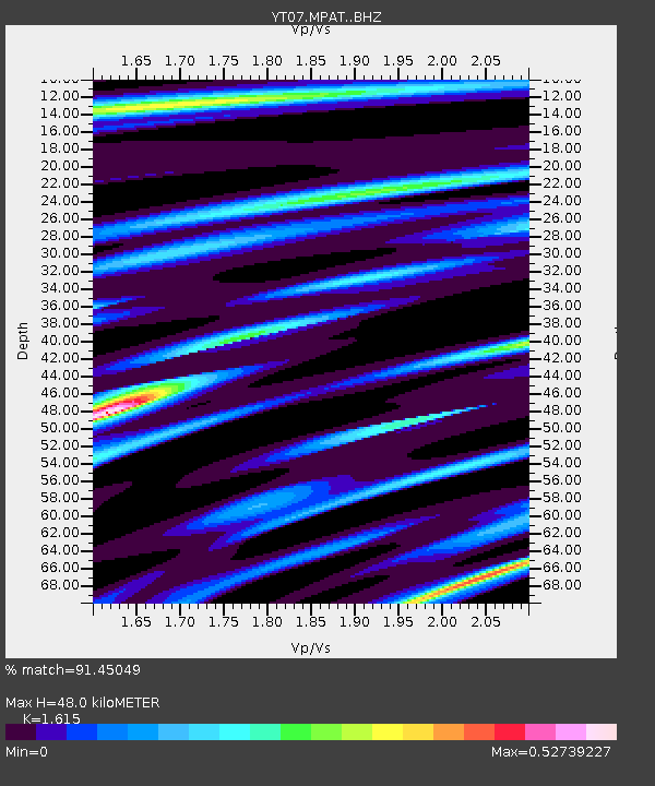
| Estimated Moho Depth: |
48.0 km |
| Estimated Crust Vp/Vs: |
1.62 |
| Assumed Crust Vp: |
6.43 km/s |
| Estimated Crust Vs: |
3.981 km/s |
| Estimated Crust Poisson's Ratio: |
0.19 |
|
| Radial Match: |
91.45049 % |
| Radial Bump: |
172 |
| Transverse Match: |
48.760666 % |
| Transverse Bump: |
360 |
| SOD ConfigId: |
11737051 |
| Insert Time: |
2019-04-25 07:57:18.270 +0000 |
| GWidth: |
2.5 |
| Max Bumps: |
400 |
| Tol: |
0.001 |
|

Signal To Noise
| Channel | StoN | STA | LTA |
| YT:MPAT: :BHZ:20160821T03:52:48.724985Z | 23.34197 | 2.3048594E-6 | 9.874314E-8 |
| YT:MPAT: :BHN:20160821T03:52:48.724985Z | 21.308409 | 1.0193558E-6 | 4.7838192E-8 |
| YT:MPAT: :BHE:20160821T03:52:48.724985Z | 13.279436 | 8.932919E-7 | 6.7268815E-8 |
| Arrivals |
| Ps | 4.9 SECOND |
| PpPs | 18 SECOND |
| PsPs/PpSs | 23 SECOND |


