You are here: Home > Network List > YT07 - POLENET Stations List
> Station SILY SILY > Earthquake Result Viewer
SILY SILY - Earthquake Result Viewer
| Earthquake location: |
South Georgia Island Region |
| Earthquake latitude/longitude: |
-55.3/-31.8 |
| Earthquake time(UTC): |
2016/08/21 (234) 03:45:23 GMT |
| Earthquake Depth: |
10 km |
| Earthquake Magnitude: |
6.4 MWP |
| Earthquake Catalog/Contributor: |
NEIC PDE/NEIC COMCAT |
|
| Network: |
YT POLENET |
| Station: |
SILY SILY |
| Lat/Lon: |
77.13 S/125.97 W |
| Elevation: |
2093 m |
|
| Distance: |
37.8 deg |
| Az: |
201.372 deg |
| Baz: |
111.497 deg |
| Ray Param: |
0.07591447 |
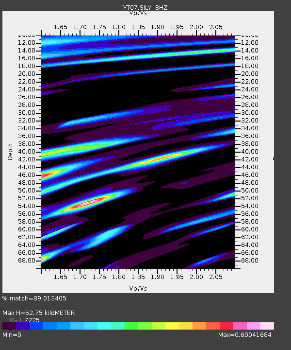
| Estimated Moho Depth: |
52.75 km |
| Estimated Crust Vp/Vs: |
1.72 |
| Assumed Crust Vp: |
6.138 km/s |
| Estimated Crust Vs: |
3.563 km/s |
| Estimated Crust Poisson's Ratio: |
0.25 |
|
| Radial Match: |
89.013405 % |
| Radial Bump: |
400 |
| Transverse Match: |
41.52075 % |
| Transverse Bump: |
400 |
| SOD ConfigId: |
11737051 |
| Insert Time: |
2019-04-25 07:57:22.183 +0000 |
| GWidth: |
2.5 |
| Max Bumps: |
400 |
| Tol: |
0.001 |
|

Signal To Noise
| Channel | StoN | STA | LTA |
| YT:SILY: :BHZ:20160821T03:52:09.54899Z | 20.021317 | 2.2238899E-6 | 1.11076105E-7 |
| YT:SILY: :BHN:20160821T03:52:09.54899Z | 1.0685606 | 8.211814E-7 | 7.6849307E-7 |
| YT:SILY: :BHE:20160821T03:52:09.54899Z | 3.8797176 | 1.279862E-6 | 3.2988535E-7 |
| Arrivals |
| Ps | 6.6 SECOND |
| PpPs | 22 SECOND |
| PsPs/PpSs | 29 SECOND |


