You are here: Home > Network List > US - United States National Seismic Network Stations List
> Station MNTX Cornudas Mountains, Texas, USA > Earthquake Result Viewer
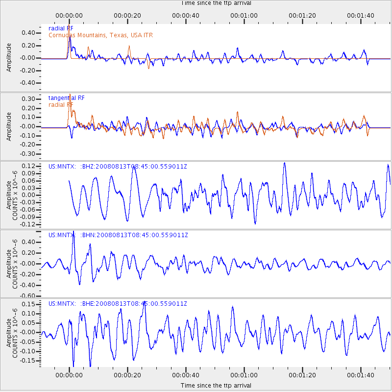
MNTX Cornudas Mountains, Texas, USA - Earthquake Result Viewer
*The percent match for this event was below the threshold and hence no stack was calculated.
| Earthquake location: |
North Of Severnaya Zemlya |
| Earthquake latitude/longitude: |
83.6/115.2 |
| Earthquake time(UTC): |
2008/08/13 (226) 08:35:02 GMT |
| Earthquake Depth: |
10 km |
| Earthquake Magnitude: |
5.5 MB, 4.7 MS, 5.4 MW, 5.4 MW |
| Earthquake Catalog/Contributor: |
WHDF/NEIC |
|
| Network: |
US United States National Seismic Network |
| Station: |
MNTX Cornudas Mountains, Texas, USA |
| Lat/Lon: |
31.70 N/105.38 W |
| Elevation: |
404 m |
|
| Distance: |
63.4 deg |
| Az: |
38.363 deg |
| Baz: |
355.344 deg |
| Ray Param: |
$rayparam |
*The percent match for this event was below the threshold and hence was not used in the summary stack. |
|
| Radial Match: |
73.65482 % |
| Radial Bump: |
400 |
| Transverse Match: |
43.215282 % |
| Transverse Bump: |
399 |
| SOD ConfigId: |
2504 |
| Insert Time: |
2010-03-05 06:18:23.679 +0000 |
| GWidth: |
2.5 |
| Max Bumps: |
400 |
| Tol: |
0.001 |
|
Signal To Noise
| Channel | StoN | STA | LTA |
| US:MNTX: :BHN:20080813T08:45:00.559011Z | 4.997079 | 2.396795E-7 | 4.7963923E-8 |
| US:MNTX: :BHE:20080813T08:45:00.559011Z | 1.9701475 | 7.751267E-8 | 3.9343586E-8 |
| US:MNTX: :BHZ:20080813T08:45:00.559011Z | 0.55609566 | 3.225458E-8 | 5.8001856E-8 |
| Arrivals |
| Ps | |
| PpPs | |
| PsPs/PpSs | |


