You are here: Home > Network List > CI - Caltech Regional Seismic Network Stations List
> Station MLAC Mammoth Lakes, California, USA > Earthquake Result Viewer
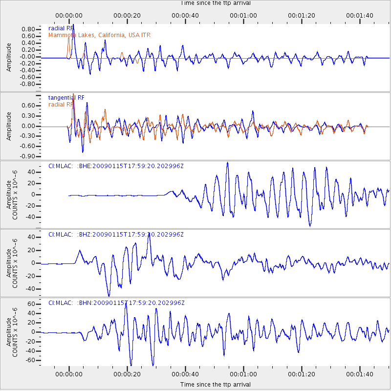
MLAC Mammoth Lakes, California, USA - Earthquake Result Viewer
*The percent match for this event was below the threshold and hence no stack was calculated.
| Earthquake location: |
East Of Kuril Islands |
| Earthquake latitude/longitude: |
46.9/155.2 |
| Earthquake time(UTC): |
2009/01/15 (015) 17:49:39 GMT |
| Earthquake Depth: |
36 km |
| Earthquake Magnitude: |
6.9 MB, 7.5 MS, 7.4 MW, 7.4 MW |
| Earthquake Catalog/Contributor: |
WHDF/NEIC |
|
| Network: |
CI Caltech Regional Seismic Network |
| Station: |
MLAC Mammoth Lakes, California, USA |
| Lat/Lon: |
37.63 N/118.84 W |
| Elevation: |
2134 m |
|
| Distance: |
61.3 deg |
| Az: |
64.542 deg |
| Baz: |
308.699 deg |
| Ray Param: |
$rayparam |
*The percent match for this event was below the threshold and hence was not used in the summary stack. |
|
| Radial Match: |
95.52999 % |
| Radial Bump: |
400 |
| Transverse Match: |
93.469666 % |
| Transverse Bump: |
400 |
| SOD ConfigId: |
2834 |
| Insert Time: |
2010-02-26 00:40:02.326 +0000 |
| GWidth: |
2.5 |
| Max Bumps: |
400 |
| Tol: |
0.001 |
|
Signal To Noise
| Channel | StoN | STA | LTA |
| CI:MLAC: :BHZ:20090115T17:59:20.202996Z | 49.139465 | 9.345382E-6 | 1.9018078E-7 |
| CI:MLAC: :BHN:20090115T17:59:20.202996Z | 6.8684196 | 2.3814882E-6 | 3.4673016E-7 |
| CI:MLAC: :BHE:20090115T17:59:20.202996Z | 5.695865 | 2.6156686E-6 | 4.5922235E-7 |
| Arrivals |
| Ps | |
| PpPs | |
| PsPs/PpSs | |


