You are here: Home > Network List > US - United States National Seismic Network Stations List
> Station MNTX Cornudas Mountains, Texas, USA > Earthquake Result Viewer
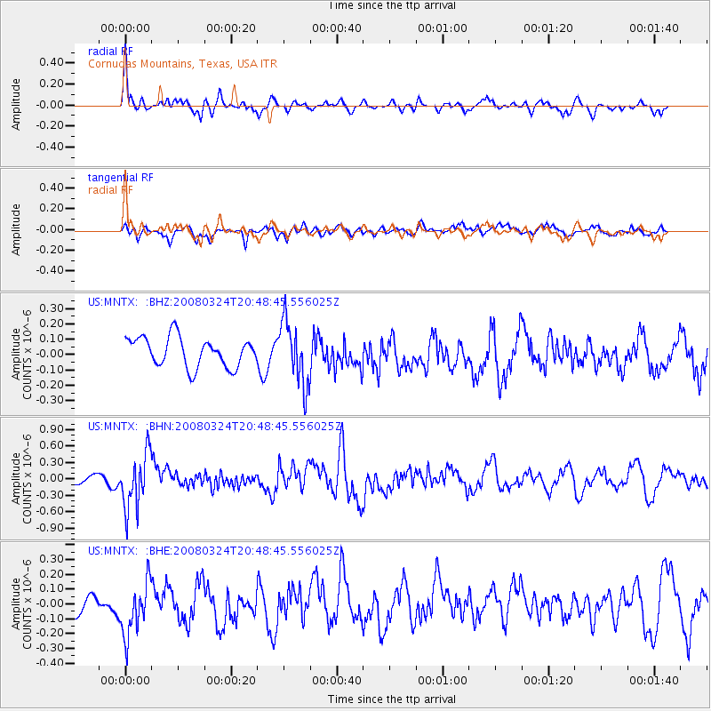
MNTX Cornudas Mountains, Texas, USA - Earthquake Result Viewer
*The percent match for this event was below the threshold and hence no stack was calculated.
| Earthquake location: |
Chile-Bolivia Border Region |
| Earthquake latitude/longitude: |
-20.0/-69.0 |
| Earthquake time(UTC): |
2008/03/24 (084) 20:39:07 GMT |
| Earthquake Depth: |
120 km |
| Earthquake Magnitude: |
5.7 MB, 6.2 MW, 6.1 MW |
| Earthquake Catalog/Contributor: |
WHDF/NEIC |
|
| Network: |
US United States National Seismic Network |
| Station: |
MNTX Cornudas Mountains, Texas, USA |
| Lat/Lon: |
31.70 N/105.38 W |
| Elevation: |
404 m |
|
| Distance: |
62.2 deg |
| Az: |
325.096 deg |
| Baz: |
140.867 deg |
| Ray Param: |
$rayparam |
*The percent match for this event was below the threshold and hence was not used in the summary stack. |
|
| Radial Match: |
75.62694 % |
| Radial Bump: |
400 |
| Transverse Match: |
68.42355 % |
| Transverse Bump: |
400 |
| SOD ConfigId: |
2504 |
| Insert Time: |
2010-03-05 06:18:24.316 +0000 |
| GWidth: |
2.5 |
| Max Bumps: |
400 |
| Tol: |
0.001 |
|
Signal To Noise
| Channel | StoN | STA | LTA |
| US:MNTX: :BHN:20080324T20:48:45.556025Z | 5.774041 | 5.0711503E-7 | 8.7826706E-8 |
| US:MNTX: :BHE:20080324T20:48:45.556025Z | 3.0560372 | 1.902668E-7 | 6.2259325E-8 |
| US:MNTX: :BHZ:20080324T20:48:45.556025Z | 2.1594124 | 2.0555048E-7 | 9.5188156E-8 |
| Arrivals |
| Ps | |
| PpPs | |
| PsPs/PpSs | |


