You are here: Home > Network List > US - United States National Seismic Network Stations List
> Station MNTX Cornudas Mountains, Texas, USA > Earthquake Result Viewer
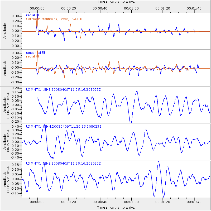
MNTX Cornudas Mountains, Texas, USA - Earthquake Result Viewer
*The percent match for this event was below the threshold and hence no stack was calculated.
| Earthquake location: |
Loyalty Islands |
| Earthquake latitude/longitude: |
-20.2/168.9 |
| Earthquake time(UTC): |
2008/04/09 (100) 11:13:17 GMT |
| Earthquake Depth: |
13 km |
| Earthquake Magnitude: |
5.6 MB, 6.3 MS, 6.4 MW, 6.3 MW |
| Earthquake Catalog/Contributor: |
WHDF/NEIC |
|
| Network: |
US United States National Seismic Network |
| Station: |
MNTX Cornudas Mountains, Texas, USA |
| Lat/Lon: |
31.70 N/105.38 W |
| Elevation: |
404 m |
|
| Distance: |
96.9 deg |
| Az: |
58.898 deg |
| Baz: |
250.672 deg |
| Ray Param: |
$rayparam |
*The percent match for this event was below the threshold and hence was not used in the summary stack. |
|
| Radial Match: |
64.075096 % |
| Radial Bump: |
244 |
| Transverse Match: |
59.955086 % |
| Transverse Bump: |
335 |
| SOD ConfigId: |
2504 |
| Insert Time: |
2010-03-05 06:18:24.970 +0000 |
| GWidth: |
2.5 |
| Max Bumps: |
400 |
| Tol: |
0.001 |
|
Signal To Noise
| Channel | StoN | STA | LTA |
| US:MNTX: :BHN:20080409T11:26:16.208025Z | 3.8338208 | 2.3026989E-7 | 6.006277E-8 |
| US:MNTX: :BHE:20080409T11:26:16.208025Z | 1.5888572 | 1.0064047E-7 | 6.334142E-8 |
| US:MNTX: :BHZ:20080409T11:26:16.208025Z | 1.1153358 | 6.95333E-8 | 6.2342934E-8 |
| Arrivals |
| Ps | |
| PpPs | |
| PsPs/PpSs | |


