You are here: Home > Network List > US - United States National Seismic Network Stations List
> Station MNTX Cornudas Mountains, Texas, USA > Earthquake Result Viewer
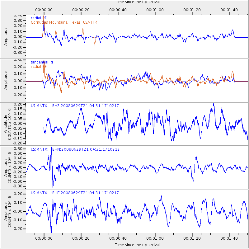
MNTX Cornudas Mountains, Texas, USA - Earthquake Result Viewer
*The percent match for this event was below the threshold and hence no stack was calculated.
| Earthquake location: |
Primor'ye, Russia |
| Earthquake latitude/longitude: |
45.2/137.4 |
| Earthquake time(UTC): |
2008/06/29 (181) 20:53:01 GMT |
| Earthquake Depth: |
287 km |
| Earthquake Magnitude: |
5.6 MB, 6.0 MW, 5.9 MW |
| Earthquake Catalog/Contributor: |
WHDF/NEIC |
|
| Network: |
US United States National Seismic Network |
| Station: |
MNTX Cornudas Mountains, Texas, USA |
| Lat/Lon: |
31.70 N/105.38 W |
| Elevation: |
404 m |
|
| Distance: |
84.6 deg |
| Az: |
49.599 deg |
| Baz: |
320.797 deg |
| Ray Param: |
$rayparam |
*The percent match for this event was below the threshold and hence was not used in the summary stack. |
|
| Radial Match: |
60.440304 % |
| Radial Bump: |
400 |
| Transverse Match: |
53.770233 % |
| Transverse Bump: |
400 |
| SOD ConfigId: |
2504 |
| Insert Time: |
2010-03-05 06:18:30.198 +0000 |
| GWidth: |
2.5 |
| Max Bumps: |
400 |
| Tol: |
0.001 |
|
Signal To Noise
| Channel | StoN | STA | LTA |
| US:MNTX: :BHN:20080629T21:04:31.171021Z | 3.7919223 | 3.339868E-7 | 8.807849E-8 |
| US:MNTX: :BHE:20080629T21:04:31.171021Z | 1.694783 | 1.0017261E-7 | 5.9106455E-8 |
| US:MNTX: :BHZ:20080629T21:04:31.171021Z | 1.1950641 | 7.6496285E-8 | 6.4010194E-8 |
| Arrivals |
| Ps | |
| PpPs | |
| PsPs/PpSs | |


