You are here: Home > Network List > US - United States National Seismic Network Stations List
> Station MNTX Cornudas Mountains, Texas, USA > Earthquake Result Viewer
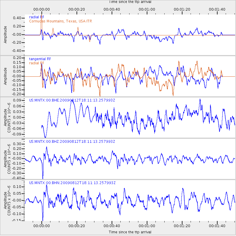
MNTX Cornudas Mountains, Texas, USA - Earthquake Result Viewer
*The percent match for this event was below the threshold and hence no stack was calculated.
| Earthquake location: |
Catamarca Province, Argentina |
| Earthquake latitude/longitude: |
-27.9/-66.7 |
| Earthquake time(UTC): |
2009/08/12 (224) 18:00:52 GMT |
| Earthquake Depth: |
174 km |
| Earthquake Magnitude: |
5.5 MW, 5.3 MB, 5.5 MW |
| Earthquake Catalog/Contributor: |
WHDF/NEIC |
|
| Network: |
US United States National Seismic Network |
| Station: |
MNTX Cornudas Mountains, Texas, USA |
| Lat/Lon: |
31.70 N/105.38 W |
| Elevation: |
404 m |
|
| Distance: |
69.8 deg |
| Az: |
325.387 deg |
| Baz: |
143.855 deg |
| Ray Param: |
$rayparam |
*The percent match for this event was below the threshold and hence was not used in the summary stack. |
|
| Radial Match: |
54.968346 % |
| Radial Bump: |
400 |
| Transverse Match: |
56.396835 % |
| Transverse Bump: |
400 |
| SOD ConfigId: |
2622 |
| Insert Time: |
2010-03-05 06:18:36.958 +0000 |
| GWidth: |
2.5 |
| Max Bumps: |
400 |
| Tol: |
0.001 |
|
Signal To Noise
| Channel | StoN | STA | LTA |
| US:MNTX:00:BHZ:20090812T18:11:13.257993Z | 3.4123323 | 1.429665E-7 | 4.1897003E-8 |
| US:MNTX:00:BHN:20090812T18:11:13.257993Z | 2.7457192 | 6.1140774E-8 | 2.2267674E-8 |
| US:MNTX:00:BHE:20090812T18:11:13.257993Z | 0.43833297 | 2.1203684E-8 | 4.837346E-8 |
| Arrivals |
| Ps | |
| PpPs | |
| PsPs/PpSs | |


