You are here: Home > Network List > US - United States National Seismic Network Stations List
> Station MNTX Cornudas Mountains, Texas, USA > Earthquake Result Viewer
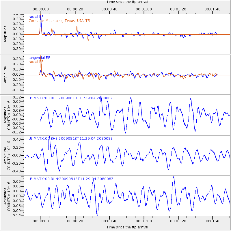
MNTX Cornudas Mountains, Texas, USA - Earthquake Result Viewer
*The percent match for this event was below the threshold and hence no stack was calculated.
| Earthquake location: |
Tonga Islands |
| Earthquake latitude/longitude: |
-21.7/-174.6 |
| Earthquake time(UTC): |
2009/08/13 (225) 11:17:01 GMT |
| Earthquake Depth: |
10 km |
| Earthquake Magnitude: |
5.6 MW, 5.3 MB |
| Earthquake Catalog/Contributor: |
WHDF/NEIC |
|
| Network: |
US United States National Seismic Network |
| Station: |
MNTX Cornudas Mountains, Texas, USA |
| Lat/Lon: |
31.70 N/105.38 W |
| Elevation: |
404 m |
|
| Distance: |
84.8 deg |
| Az: |
53.129 deg |
| Baz: |
240.813 deg |
| Ray Param: |
$rayparam |
*The percent match for this event was below the threshold and hence was not used in the summary stack. |
|
| Radial Match: |
78.81331 % |
| Radial Bump: |
389 |
| Transverse Match: |
62.640095 % |
| Transverse Bump: |
400 |
| SOD ConfigId: |
2622 |
| Insert Time: |
2010-03-05 06:18:37.698 +0000 |
| GWidth: |
2.5 |
| Max Bumps: |
400 |
| Tol: |
0.001 |
|
Signal To Noise
| Channel | StoN | STA | LTA |
| US:MNTX:00:BHZ:20090813T11:29:04.208008Z | 6.0247006 | 2.1718259E-7 | 3.6048696E-8 |
| US:MNTX:00:BHN:20090813T11:29:04.208008Z | 1.7057925 | 3.4661593E-8 | 2.0319934E-8 |
| US:MNTX:00:BHE:20090813T11:29:04.208008Z | 1.3894873 | 4.9570264E-8 | 3.5675217E-8 |
| Arrivals |
| Ps | |
| PpPs | |
| PsPs/PpSs | |


