You are here: Home > Network List > AV - Alaska Volcano Observatory Stations List
> Station AMKA Regional Station, Amchitka Island, Alaska > Earthquake Result Viewer
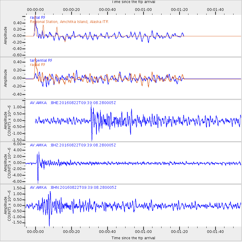
AMKA Regional Station, Amchitka Island, Alaska - Earthquake Result Viewer
*The percent match for this event was below the threshold and hence no stack was calculated.
| Earthquake location: |
Southeast Of Honshu, Japan |
| Earthquake latitude/longitude: |
29.9/139.1 |
| Earthquake time(UTC): |
2016/08/22 (235) 09:33:08 GMT |
| Earthquake Depth: |
404 km |
| Earthquake Magnitude: |
5.6 MB |
| Earthquake Catalog/Contributor: |
NEIC PDE/NEIC COMCAT |
|
| Network: |
AV Alaska Volcano Observatory |
| Station: |
AMKA Regional Station, Amchitka Island, Alaska |
| Lat/Lon: |
51.38 N/179.30 E |
| Elevation: |
116 m |
|
| Distance: |
36.6 deg |
| Az: |
42.632 deg |
| Baz: |
249.787 deg |
| Ray Param: |
$rayparam |
*The percent match for this event was below the threshold and hence was not used in the summary stack. |
|
| Radial Match: |
68.36585 % |
| Radial Bump: |
400 |
| Transverse Match: |
72.29818 % |
| Transverse Bump: |
400 |
| SOD ConfigId: |
11737051 |
| Insert Time: |
2019-04-25 07:59:58.992 +0000 |
| GWidth: |
2.5 |
| Max Bumps: |
400 |
| Tol: |
0.001 |
|
Signal To Noise
| Channel | StoN | STA | LTA |
| AV:AMKA: :BHZ:20160822T09:39:08.280005Z | 10.56053 | 1.6787807E-6 | 1.5896747E-7 |
| AV:AMKA: :BHN:20160822T09:39:08.280005Z | 2.2376525 | 2.719793E-7 | 1.2154672E-7 |
| AV:AMKA: :BHE:20160822T09:39:08.280005Z | 4.222667 | 5.497265E-7 | 1.3018467E-7 |
| Arrivals |
| Ps | |
| PpPs | |
| PsPs/PpSs | |


