You are here: Home > Network List > US - United States National Seismic Network Stations List
> Station MNTX Cornudas Mountains, Texas, USA > Earthquake Result Viewer
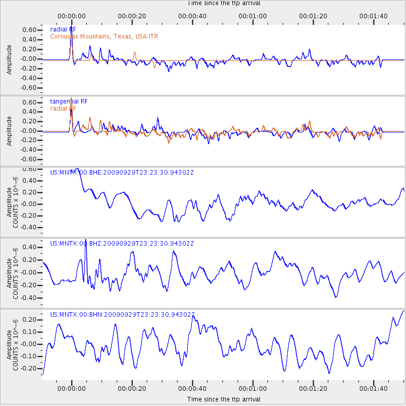
MNTX Cornudas Mountains, Texas, USA - Earthquake Result Viewer
*The percent match for this event was below the threshold and hence no stack was calculated.
| Earthquake location: |
Tonga Islands |
| Earthquake latitude/longitude: |
-15.6/-173.4 |
| Earthquake time(UTC): |
2009/09/29 (272) 23:11:51 GMT |
| Earthquake Depth: |
10 km |
| Earthquake Magnitude: |
5.5 MB |
| Earthquake Catalog/Contributor: |
WHDF/NEIC |
|
| Network: |
US United States National Seismic Network |
| Station: |
MNTX Cornudas Mountains, Texas, USA |
| Lat/Lon: |
31.70 N/105.38 W |
| Elevation: |
404 m |
|
| Distance: |
80.3 deg |
| Az: |
53.29 deg |
| Baz: |
244.993 deg |
| Ray Param: |
$rayparam |
*The percent match for this event was below the threshold and hence was not used in the summary stack. |
|
| Radial Match: |
72.921684 % |
| Radial Bump: |
400 |
| Transverse Match: |
50.805435 % |
| Transverse Bump: |
309 |
| SOD ConfigId: |
2622 |
| Insert Time: |
2010-03-05 06:18:45.871 +0000 |
| GWidth: |
2.5 |
| Max Bumps: |
400 |
| Tol: |
0.001 |
|
Signal To Noise
| Channel | StoN | STA | LTA |
| US:MNTX:00:BHZ:20090929T23:23:30.94302Z | 1.0918604 | 1.8369398E-7 | 1.6823945E-7 |
| US:MNTX:00:BHN:20090929T23:23:30.94302Z | 0.661697 | 6.9786466E-8 | 1.05465894E-7 |
| US:MNTX:00:BHE:20090929T23:23:30.94302Z | 1.3927553 | 3.095109E-7 | 2.2222922E-7 |
| Arrivals |
| Ps | |
| PpPs | |
| PsPs/PpSs | |


